


1:30 p.m. update
A special weather statement was issued for parts of Allegan, Barry, and Kent counties, including the communities of Hopkins, Wayland, Middleville, and Caledonia. Pea-sized hail and 40 mile per hour winds are possible with a line of storms moving north-northeast, according to the National Weather Service.
The statement is set to expire at 2:15 p.m.
A special weather statement has been issued for Wayland MI, Middleville MI and Caledonia MI until 2:15 PM EDT pic.twitter.com/MBYr4yYOpl
— NWS Grand Rapids (@NWSGrandRapids) March 31, 2026
A similar Special Weather Statement was issued for parts of Newaygo and Mecosta counties.
A special weather statement has been issued for Big Rapids MI, Canadian Lakes MI and White Cloud MI until 2:15 PM EDT pic.twitter.com/VYxSYTRwMl
— NWS Grand Rapids (@NWSGrandRapids) March 31, 2026
11:14 a.m. update
A special weather statement was issued for Mason and Oceana counties. The National Weather Service said penny-sized hail and 40 mile-per-hour winds are possible with a line of thunderstorms rolling off of Lake Michigan.
The special statement is in effect until noon.
A special weather statement has been issued for Ludington MI, Hart MI and Shelby MI until 12:00 PM EDT pic.twitter.com/h3o9lHt4we
— NWS Grand Rapids (@NWSGrandRapids) March 31, 2026
There was also a Special Marine Warning put in effect for several square-nautical miles of Lake Michigan near those counties.
Special Marine Warning including the Lake Michigan from Whitehall to Pentwater MI 5NM offshore to Mid Lake, Lake Michigan from Pentwater to Manistee MI 5NM offshore to Mid Lake, Pentwater to Manistee MI and Whitehall to Pentwater MI until 12:15 PM EDT pic.twitter.com/VwwkddYkGc
— NWS Grand Rapids (@NWSGrandRapids) March 31, 2026
11:04 a.m. Initial Article
The National Weather Service set a Severe Thunderstorm Watch for five counties along the Michigan-Indiana border, including Berrien, Cass, St. Joseph, Branch, and Hillsdale counties. The watch is in effect until 6 p.m. on March 31, 2026.
A severe thunderstorm watch has been issued for parts of Illinois, Indiana, Michigan and Ohio until 6 PM EDT pic.twitter.com/TKaaEIazWg
— NWS Northern Indiana (@NWSIWX) March 31, 2026
READ MORE:
Watches and Warnings: What's the difference?
How severe thunderstorms are measured
A watch means severe weather is possible. A warning means that severe weather is happening, and you need to take action.
A good way to remember the difference is by thinking of cupcakes!
During a "cupcake watch", we have all of the ingredients available to make a cupcake. We have the eggs, the flour, the sugar, and the salt. However, we don't have a cupcake just yet. We need the exact amount of each ingredient to make a cupcake. We're watching to see if the recipe comes together. Watching allows us to be proactive and not surprised if something comes together.
WATCH: Chief Meteorologist Kevin Craig breaks down the Severe Thunderstorm Watch
The FOX 17 Weather Ready Meteorologists declared a Weather Ready Alert for Tuesday, March 31 because of the chance of severe weather. Multiple rounds of rain and thunderstorms are forecasted and some could be strong to severe.
The southern half of the state is in a Slight risk (level 2/5) for severe weather for this afternoon/evening. Hail and damaging winds remain the primary threats with any of these storms that develop. There is a low isolated tornado threat! Some heavy downpours will be possible too.
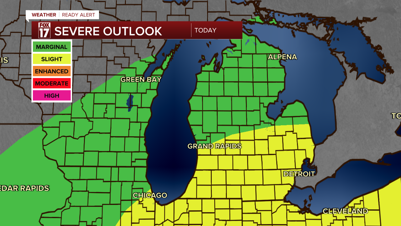
The time frame for rain and storm activity will be between 2PM-10PM. This could impact the afternoon/evening commute, so plan accordingly.
Want alerts when inconvenient or severe weather is headed your way? Download the FOX 17 Weather app and set up notifications for where you live.
For the latest details on the weather in West Michigan, head to the FOX 17 Weather page.
Follow FOX 17: Facebook - X (formerly Twitter) - Instagram - YouTube
