

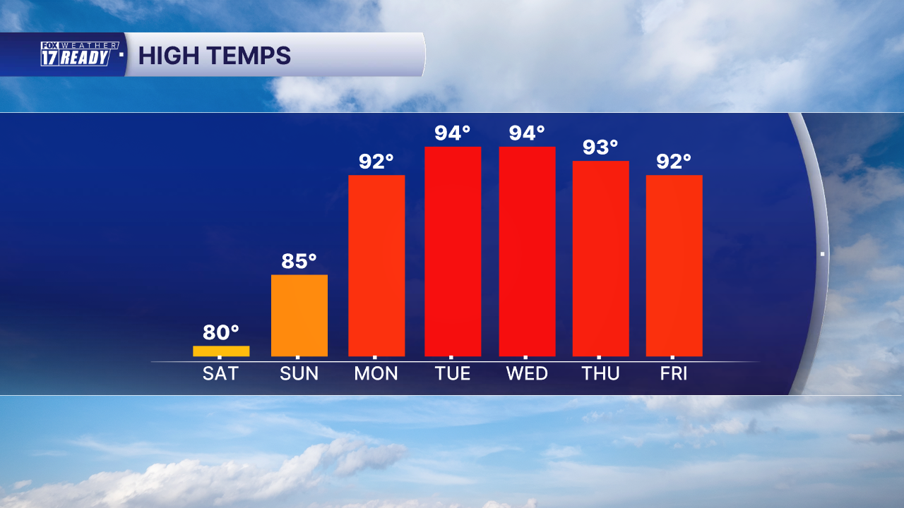
While this has been the coolest June in 6 years, the summer sizzle is just around the corner. We have not yet hit 90 degrees this year (the hottest day was June 10, at 89 degrees) but a string of 90 degree days are expected starting Monday, with increasing humidity pushing heat index values up into the low 100s.
A massive ridge of high pressure is building in the upper atmosphere, anchoring itself over the Ohio and Tennessee Valleys. The position of this high brings wind from the south to West Michigan, drawing up hot and humid air and leading to primarily dry days.

Temperatures will increase a degree or two each day from Monday onward as the ridge is parked overhead. Tuesday and Wednesday will be the hottest days at 94 degrees, with some spots inching into the upper 90s.
And it's not just afternoon high temperatures that will be soaring...overnight temperatures will only fall into the low to mid 70s. This doesn't allow for much heat recovery and can add to heat stress concerns.
As if the heat is not enough, when we factor in the high dew points and moisture levels, heat index temperatures for these same days soar into the low 100s. Multiple days of heat indices in the low 100s can stress our bodies. Make sure you stay cool and hydrated during this heat wave.

It may seem obvious, but some tips to help beat the heat:
- Drink water! More than you think you need to. In hot, humid weather it's harder for our bodies to cool down via sweat evaporation.
- Take breaks in the shade, or better yet in air conditioning
- Wear light colored, loose clothes
- Limit time outdoors between 9 am and 7 pm
With several days in a row of extreme heat and humidity, the heat risk climbs into the Major and Extreme categories for much of this upcoming week.

The heat risk is a measure of how affected daily life can be in the midst of prolonged heat and humidity. When Major (red) and Extreme (purple) levels are reached, it becomes dangerous for anyone to be inside during the afternoon and early evening without air conditioning. Fans do not work to cool your home or indoor space at these levels of heat and humidity.
Those especially vulnerable to heat related illnesses during these multi-day heat waves include the elderly and very young, unhoused people, and outdoor workers. Check on your neighbors!
Want alerts when inconvenient or severe weather is headed your way? Download the FOX 17 Weather app and set up notifications for where you live.
For the latest details on the weather in West Michigan, head to the FOX 17 Weather page.
Follow FOX 17: Facebook - X (formerly Twitter) - Instagram - YouTube
