


WEST MICHIGAN — The forecast from FOX 17 Weather Ready Meteorologist Colton Cichoracki: Mother's Day saw some nice but cool weather in West Michigan with temperatures in the 50s and 60s. Another cold night is in store for the area Sunday night and a Frost Advisory has been issued for most of West Michigan. A Freeze Warning has been issued for Oceana, Mecosta, and Newaygo counties as well. Temperatures overnight will drop into the 30s so make sure you cover up any of your plants outside! The work week will start off with more below average temperatures on Monday with highs in the upper 50s to lower 60s. It will also be sunny and dry. Frost will be possible once again Monday night with lows in the mid 30s. Our next chance for rain and possibly a few thunderstorms comes Tuesday afternoon. Showers will continue Tuesday evening/night, potentially lingering into early Wednesday. Temperatures take a step back Wednesday into the 50s but a major pattern flip will begin Thursday as a very big warm-up is coming to West Michigan by the end of the week and into the weekend.
TONIGHT: Frost Advisory until 8 AM. Partly cloudy to mostly clear, areas of frost possible. Lows in the mid 30s. N wind at 5-10 mph.
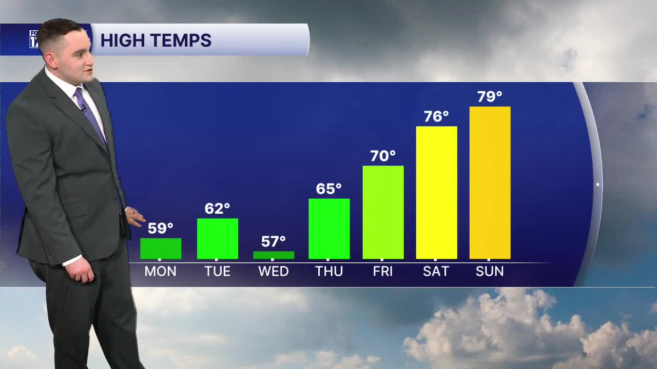
MONDAY: Frost early. Mostly sunny. Highs in the upper 50s. NE wind turning NW at 5-10 mph.
TUESDAY: Frost possible early. Mostly cloudy with afternoon/evening showers and t-storms likely. Breezy. Highs in the lower 60s.
WEDNESDAY: Chance A.M. showers, then mostly cloudy. Breezy. Highs in the upper 50s.
THURSDAY: Mostly sunny. Highs in the mid 60s.
FRIDAY: Chance showers, partly cloudy. Warmer, highs around 70.
SATURDAY: Partly cloudy. Highs in the mid 70s.
SUNDAY: Partly cloudy. Very warm. Highs in the upper 70s to lower 80s.
Want alerts when inconvenient or severe weather is headed your way? Download the FOX 17 Weather app and set up notifications for where you live.
For the latest details on the weather in West Michigan, head to the FOX 17 Weather page.
Follow FOX 17: Facebook - X (formerly Twitter) - Instagram - YouTube
