

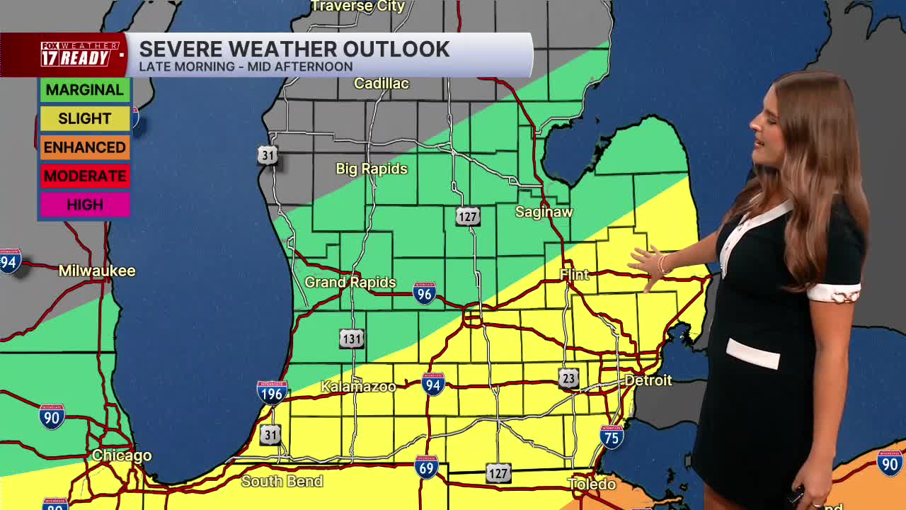



WEST MICHIGAN — The forecast from FOX 17 Weather Ready Meteorologist Gracyn Freund: Scattered showers and storms will move through along a cold front between this morning through mid-afternoon. There is a Marginal Risk in place from Big Rapids down towards I-94, and a Slight Risk for I-94 and south. Damaging winds and heavy rain will be the primary threats with any storms, but they should pass through quickly. Winds will turn back out of the northwest behind the front which will pull the smoke back into our area from the north later in the day, overnight, and through Sunday, so make sure to check the air quality in your area before going outside. The Air Quality Alert remains in place statewide through today to account for thick smoke and poor air quality, as levels in West Michigan are expected to drop to "unhealthy for sensitive groups" to "unhealthy for all". We have extended the Weather Ready Alert through today as well. Another system Monday into Tuesday brings a better chance of widespread rain and storms, including the potential for a few strong storms west of US-131. Much cooler air will filter in next week, with highs in the upper 70s and low 80s plus lower humidity. Finally some relief from the heat!
TODAY: WEATHER READY ALERT & AIR QUALITY ALERT: Partly cloudy with scattered showers and storms, a few strong/severe storms possible in the early afternoon. Then turning mostly sunny. Highs in the mid/upper 80s. Wind W/NW at 10-20 mph.
TONIGHT: Mostly clear with patchy smoke. Lows in the lower 60s. Wind N/NE at 5-10 mph.
SUNDAY: Mostly sunny and likely smoky. Highs in the middle 80s.
MONDAY: Partly cloudy with P.M. scattered showers and storms, some strong/severe possible. Highs in the mid/upper 80s.
TUESDAY: A.M. showers and storms, then partly cloudy. Highs in the low 80s.
WEDNESDAY: Partly cloudy and cooler. Highs in the upper 70s.
THURSDAY: Mostly sunny with highs in the lower 80s.
FRIDAY: Partly cloudy with highs in the low 80s.
Want alerts when inconvenient or severe weather is headed your way? Download the FOX 17 Weather app and set up notifications for where you live.
For the latest details on the weather in West Michigan, head to the FOX 17 Weather page.
Follow FOX 17: Facebook - X (formerly Twitter) - Instagram - YouTube
