


WEST MICHIGAN - Wet and heavy snow has started falling over Southwest Michigan this evening. This storm will mainly impact the Friday evening commute due to reduced visibility concerns and slick roadways. Snow rates could range up to 2" per hour near I-94. We also know winds will ramp up with this system, with wind gusts up to 45 mph. This will be a quick-hitting system. With temperatures in the 30s, this will likely have a thick, wet, heavy, high-moisture content snow consistency. A good packing snow to be sure!
Based on the latest model runs, 6" to 10" or more of snow accumulation will be possible south of I-96, closer to I-94. Lesser amounts are likely north of Grand Rapids since this system has shifted further into Ohio. It's possible some brief rain (to a lesser degree freezing rain) may mix in, but the dominant precipitation is expected to be snow.
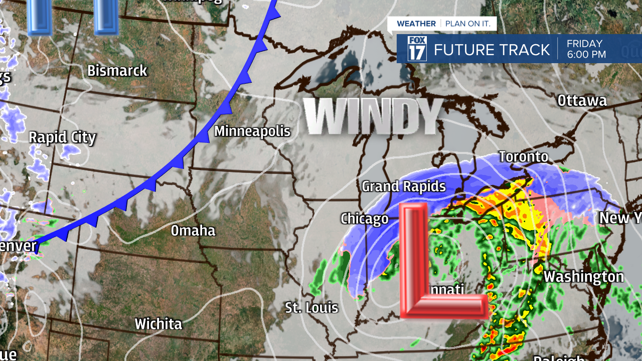
The image below valid at 6 P.M. shows our Friday evening commute will be significantly impacted by this system. Heavy snow at that time is likely and travel is not advised.
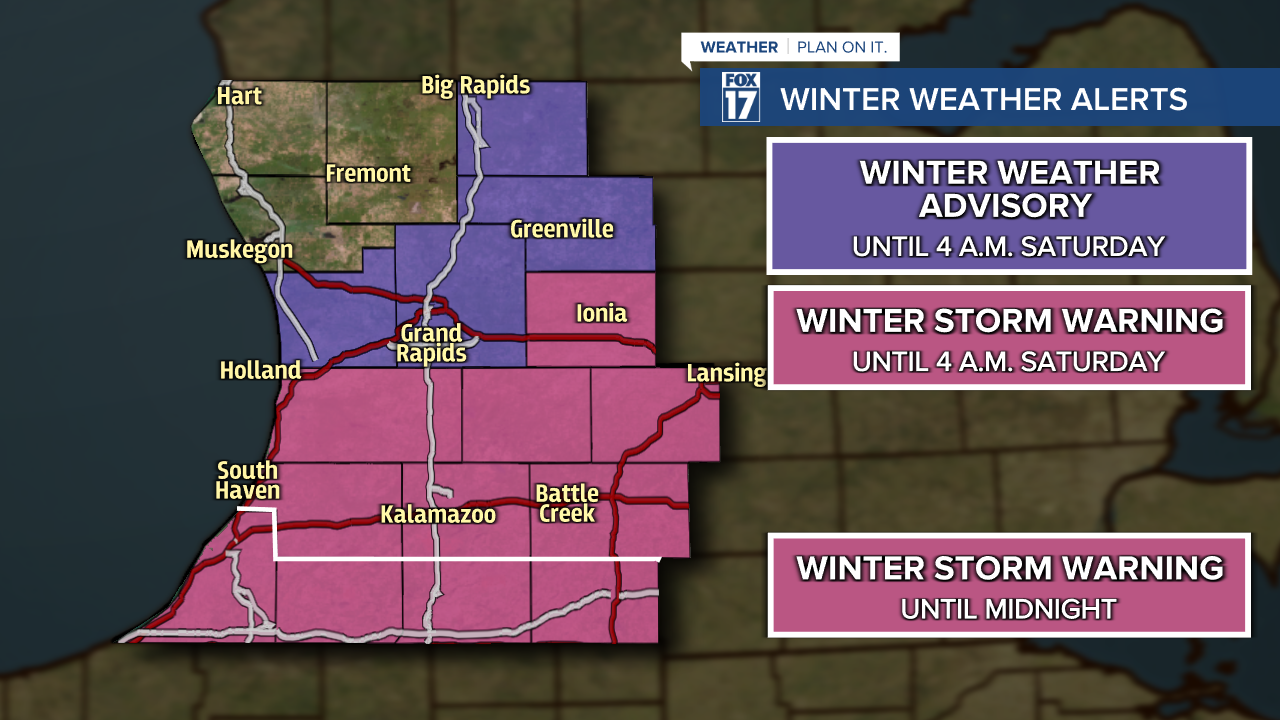
A WINTER WEATHER ADVISORY has been posted for Kent, Mecosta, Montcalm and Ottawa counties until 4 a.m. Saturday. Total snow accumulation in this zone could range between 2" to 4" with isolated higher amounts.
A WINTER STORM WARNING has been posted for Allegan, Barry, Clinton, Eaton, Ingham, Ionia, Van Buren, Kalamazoo, Calhoun, and Jackson counties until 4 a.m. Saturday. Total snow accumulation over 6" up to a foot or more will be possible under these counties.
A WINTER STORM WARNING has been posted for Berrien, Branch, Cass, and St. Joseph counties from noon today through midnight. Total snow accumulation over 6" up to a foot or more will be possible under these counties.
Below is our hand drawn snow map. We believe the heaviest snow will be closer to I-94. The darker blue indicates snow totals of 6" to 10"+ of snow, while lighter amounts are anticipated north/west of Grand Rapids. We also expect that a few areas in the dark blue may very well approach or exceed a foot of snow where the best lift and meso-scale banding sets up with this dynamic system. There is likely to be a very sharp gradient or cut-off within the 1" to 2" and 3" to 6" range. We would expect over the course of just five to ten miles, will likely make the difference between snow and no snow, or light snow versus heavy snow.

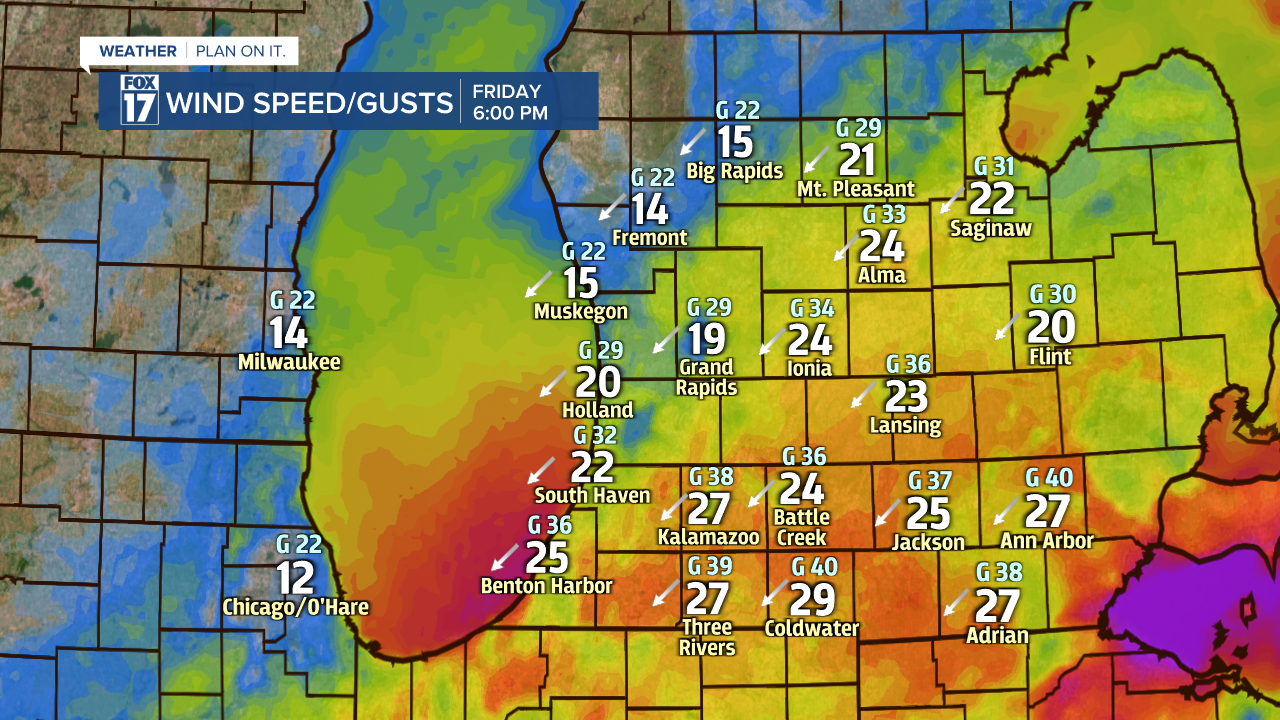
As this system lifts north into the Great Lakes, it will strengthen and its winds will increase. There is the possibility of 40 to 45 mph wind gusts on Friday that will accompany the heavy precipitation. See wind speeds, gusts, and direction below.
If the heavy snow comes to fruition for some areas, we could be looking at brief white-out conditions at times with strong, gusty winds! At points, snow could fall at the rate of one inch per hour!
Make sure to stay up on later forecasts as the track of this system will ultimately determine the amount of precipitation we see. Don't forget to download the FOX 17 WEATHER APP for watches, warnings, advisories, radar, and more.
Get the complete West Michigan forecast at www.fox17online.com/weather.
