


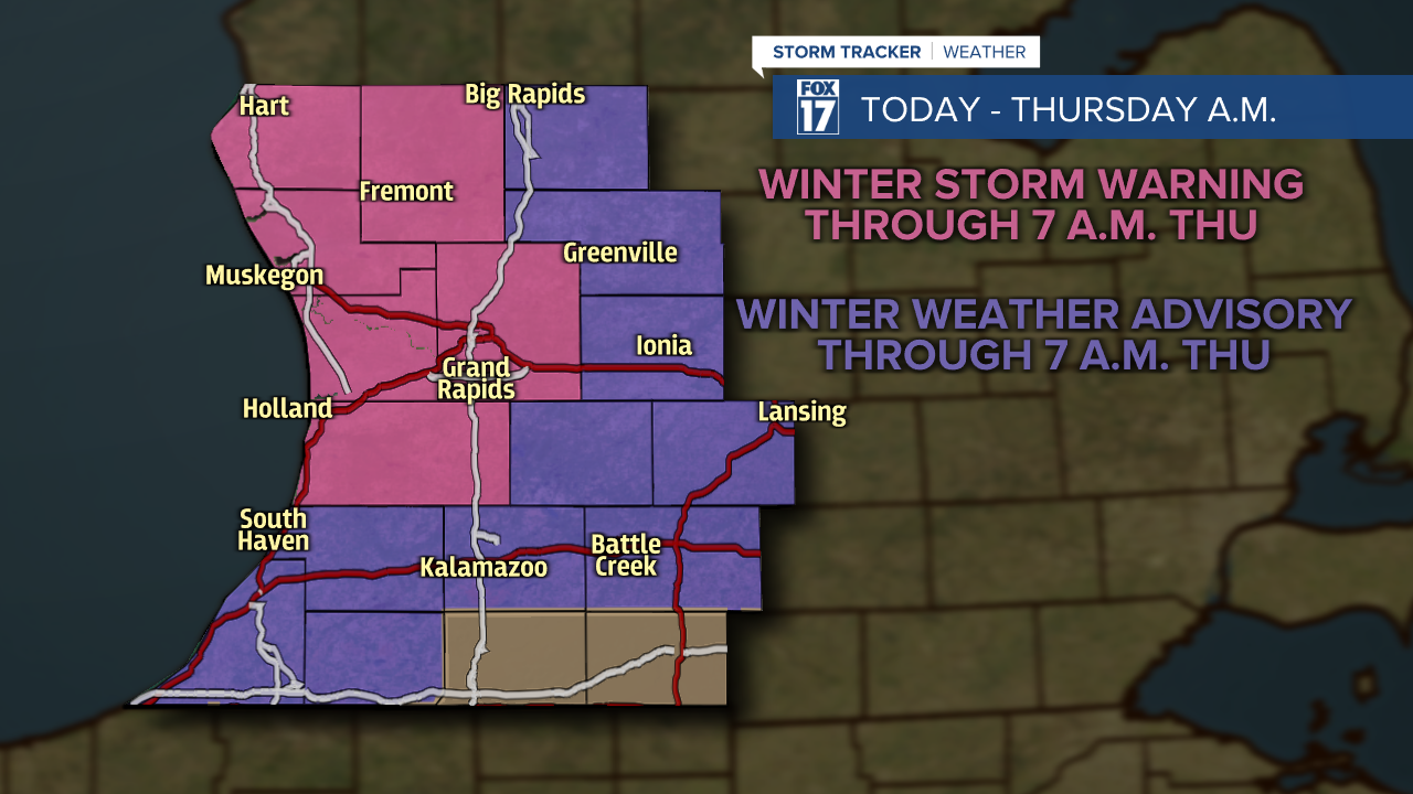
WINTER STORM WARNING posted for Allegan, Kent, Muskegon, Newaygo, Oceana, Ottawa Counties from are in effect through 7 AM Thursday. Wind, falling temps, blowing and drifting snow, near white-out conditions. 4" to 8" accumulation with locally higher amounts possible.
WINTER WEATHER ADVISORY posted for Barry, Ionia, Kalamazoo, Mecosta, Montcalm, Van Buren, Osceola, Berrien, and Cass Counties are in effect through 7 AM Thursday. Similar situation as above, but 2" to 4" accumulation.
WINTER WEATHER ADVISORY posted for Gratiot, Clinton, Eaton, Ingham, Calhoun, and Jackson counties are in effect through through 7 AM Thursday. Similar situation as above, but up to 2" of snow accumulation.
Leave your snow shovels, winter gear, and hand warmers close by ... another round of frigid air, snow, and strong winds are moving into West Michigan.
Conditions are quiet this morning, but the system will continually build in for the day. By daybreak on Wednesday, snow builds into the region.

Snow showers will become the most widespread by Wednesday afternoon and evening, as the central low pressure shifts towards the northeast.

In addition to steady snow showers during the Wednesday evening commute, there will additionally be strong winds from the west-northwest. Sustained winds will range between 20 to 30 mph, with wind gusts up to 50 mph along the lakeshore. Blowing and drifting snow will be a concern Wednesday evening, along with low to zero visibility.

When factoring in the wind and the already cold temperatures, feels like temperatures will fall into the single digits for most. Some locations near I-94 could have feels like temperatures below zero. If you must spend an extended amount of time outdoors on Wednesday, Thursday, or Friday, make sure you cover any exposed skin.

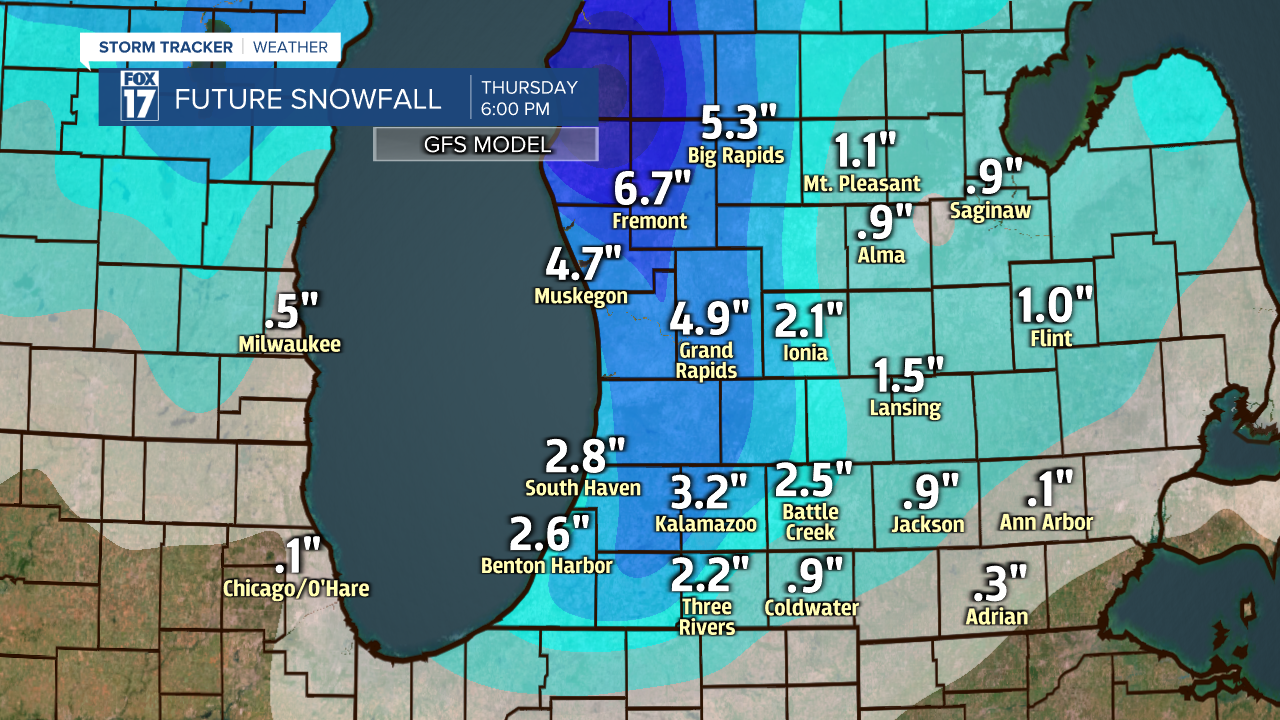
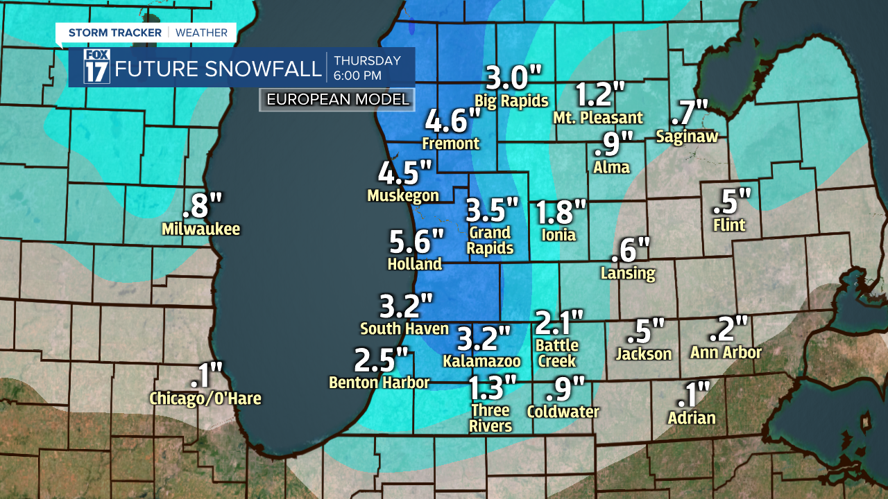
Last, but not least, the snow totals. Initial reports have the most snow accumulation expected along and west of US-131. Please keep in mind when reading these projected snow totals that it includes Wednesday, Thursday, and Friday. This snow accumulation ranges between 6 a.m. Wednesday morning through 6 p.m. Friday evening for both models.
When comparing the EURO model and GFS model, both are in agreement that we could see the highest snow accumulation along and west of US-131. The GFS model suggests the highest snow totals near Grand Rapids, Muskegon, and Fremont. Probably on the order of 3" to 6", with 2" to 4" east of US-131.
The EURO model also suggests that the highest snow totals in our lakeshore communities.
Our GRAF Model below shows areas along/west of U.S. 131 will likely see the highest snow totals.

As you can see, there is a difference in snow total approximation between models. When it comes to lake effect snow, models aren't always the most spot-on. A heavy lake effect snow band can line up, dumping several inches in one town and only an inch in a town a couple miles over. This is very typical of West Michigan weather! Take a look at our hand drawn snow map below. We believe a general 4" to 8" will fall in the WARNING areas from Grand Rapids north and west, while 2" to 4" is likely further east of U.S. 131 in the ADVISORY areas. The dominant west-southwest wind will help to scoop moisture from Lake Michigan and create a significant "lake enhancement" with this system. Note the heaviest snow totals line up with the Winter Storm warnings.

Make sure to stay up on later forecasts. Regardless of snow totals, roads will be impacted! Reduced visibility will be likely, along with bitter cold temperatures. Stay safe and stay bundled up! Get maps and the complete forecast at www.fox17online.com/weather.
