

WEST MICHIGAN — As I outlined in a post on Saturday evening (read that story here) our threat for severe weather was steadily increasing for Monday afternoon and evening. Several severe weather parameters are coming together and many of the severe weather indices we look at during these types of event are fairly high on the charts. The National Weather Service in Grand Rapids actually stated “a possible severe weather outbreak is being watched for today. Significant thunderstorm development is possible with wind gusts of 75 mph or greater.”
The Storm Prediction Center in Norman, Oklahoma is the branch of NOAA that produces the severe weather outlooks we see all year long. Their main purpose is to highlight areas around the country on a daily basis that may experience severe storms one, two, or three days in advance. These convective outlooks have five categories: marginal, slight, enhanced, moderate, and high. All of lower Michigan is currently in an “enhanced risk” with clusters of intense storms and/or strong tornadoes possible.
SPC forecasters were actually considering upgrading our risk to “moderate”, but declined due to the uncertainty of how these storms will continue to evolve. Extensive cloud cover across our area will limit the severe threat, but the other concern is that a complex (or MCS for you weather geeks) of storms west of Michigan will move in to the area this afternoon. These storms have already had a history of producing 70 to 80 mph winds and at least one inch size hail. Below is the weather map and surface features (cold front, warm front, highs, lows) valid on Monday at 8:00 P.M..

As the headline reads, this is clearly our best chance (thus far this year) for the possibility of widespread severe storms (including tornadoes) across our FOX 17 viewing area. Please keep a NOAA weather radio handy or stay close to FOX 17. The best time for several storms at this point would be this afternoon and again in the evening associated with the arrival of the cold front.
As a meteorologist I will say this: there is some conjecture on social media that Lake Michigan will knock the power and energy out of these storms if/when they come across the lake. In the synoptic (large-scale) situation that we will be in, moisture, lift, instability, the arrival of a low pressure system and cold front, and elevated severe weather indices, these storms likely can/will overcome the small influence of the colder waters of Lake Michigan.
As I have stated many times in the past…West Michigan is way overdue for a severe weather outbreak. I hope this will not be the one, but please be prepared and keep and eye to the sky today! Get the complete forecast and updates at www.fox17online.com/weather. The next update from the Storm Prediction Center on our outlook will be issued at 12:30 P.M.. Click here to see it.
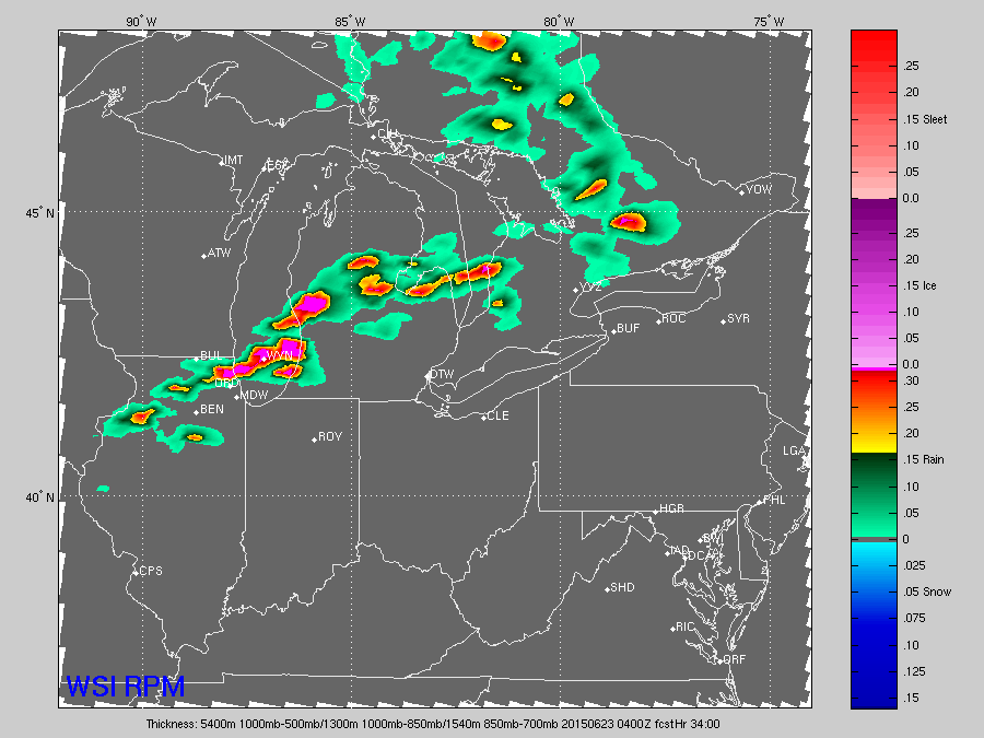
Our forecast model has two rounds of severe storms possible today. The first image below is valid around 2:00 PM Monday.

The next image below is valid for around midnight on Monday/Tuesday morning. It’s important to note that these images are not necessarily reality, but what the forecast model believes will happen. The areas in red and magenta are severe with heavy rain, hail, damaging winds, and perhaps tornadic cells. Don’t get caught up in the actual placement. We look at these forecast models for the overall picture of things and a general time frame.
Remember that a SEVERE THUNDERSTORM WATCH means that conditions are favorable for the development of severe storms producing at least 58 mph winds or greater and/or one inch size hail or larger. A TORNADO WATCH means that conditions are favorable for the development of tornadoes.
A SEVERE THUNDERSTORM WARNING means that thunderstorms capable of producing 58 mph winds or greater and/or one inch size hail or larger is occurring. Recall that severe thunderstorms can/do spawn tornadoes. A TORNADO WARNING means that either a tornado has been spotted, or radar is indicating rotation or the possibility of one. The safest place to be during a tornado is on the lowest level, away from windows, and preferably underneath something that can protect you from falling debris. Lightning and rain are not severe criteria for severe warnings, but both can kill! If you can hear thunder, move indoors. Lightning can strike from several miles away from a storm. You can get more safety tips directly from the National Weather Service here.
