


WEST MICHIGAN — As Christmas approaches this year, the Great Lakes is dealing with a major winter storm. Blizzard Warnings, Winter Storm Warnings, and Winter Weather Advisories are in effect. To put this system into perspective and show the scope and magnitude of it, consider this. The last time blizzard warnings were issued this widespread across the area was for the Groundhog's Day Blizzard in 2011. This storm will be similar or worse than that one! It is not expected to rival or surpass the blizzards of 1967 or 1978 on a broad scale. The '78 blizzard (the benchmark) had a very deep low pressure area and hurricane force winds between 70 and 90 mph in the Northeast United States. They were not that strong here locally. Take a look at all of the warnings/advisories related to this system. See image below. Most of the lower 48 states are impacted! It's incredible that Arctic air with wind chills below zero will penetrate as far south as Texas, the Gulf Coast, and Florida!

Below are our local warnings for this storm system.
A BLIZZARD WARNING is in effect for Berrien, Cass, Oceana, Newaygo, Muskegon, Ottawa, Kent, Allegan, Barry, Van Buren Kalamazoo, and St. Joseph counties until 7 p.m. this evening.
A WINTER STORM WARNING is in effect for Eaton, Ingham, Calhoun, and Jackson counties until 7 p.m. this evening.
A WINTER STORM WARNING is in effect for Branch and Hillsdale counties until 1 p.m. this evening.
Lastly, a WINTER WEATHER ADVISORY is in effect for Mecosta, Montcalm, and Ionia counties until 7 p.m. this evening.
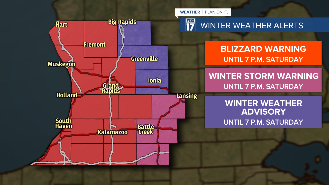
Some have asked why a Blizzard Warning was not issued for the entire area. Three simple reasons. One, winds will be a bit weaker where the Winter Storm Warnings are in effect across our eastern counties. Two, snow will be slightly less. Three, blizzard criteria of three hours or more with visibilities of a quarter mile or less will not be met in those locations. The main concerns with this winter storm include widespread heavy snow, strong wind gusts, bitter cold temperatures, and hazardous travel conditions. The wind gusts will generate blowing and drifting snow, which will create white-out conditions at times. This will be a moderate to high impact winter storm across the entire area and much of the state!
Travel conditions will continue to be tough into early Saturday as snow becomes heavier and the winds become stronger. Heavy, wind driven snow with significant blowing and drifting will create blizzard conditions. The snow itself will be a light/fluffy/powdery/low-moisture content consistency, which means very easy to blow and drift. Wind gusts of more than 50 mph will be likely. Power outages are possible.
Our forecast models have been consistently showing the likely of double digit totals. See image below of what we think will fall through Sunday, which is Christmas Day. Because this system will drive lake effect snow, totals will be higher along/west of U.S. 131 and south/west of Grand Rapids.

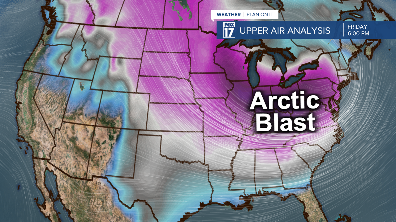
This system will eventually lift into central Canada Christmas Day, which will allow lake effect to slowly taper off and winds to relax. Take a look at the colors on the map below. They represent air masses. The Arctic air can be seen in pink, purple, and magenta. Notice that it penetrates more than a thousand miles south into Texas and the Gulf Coast.
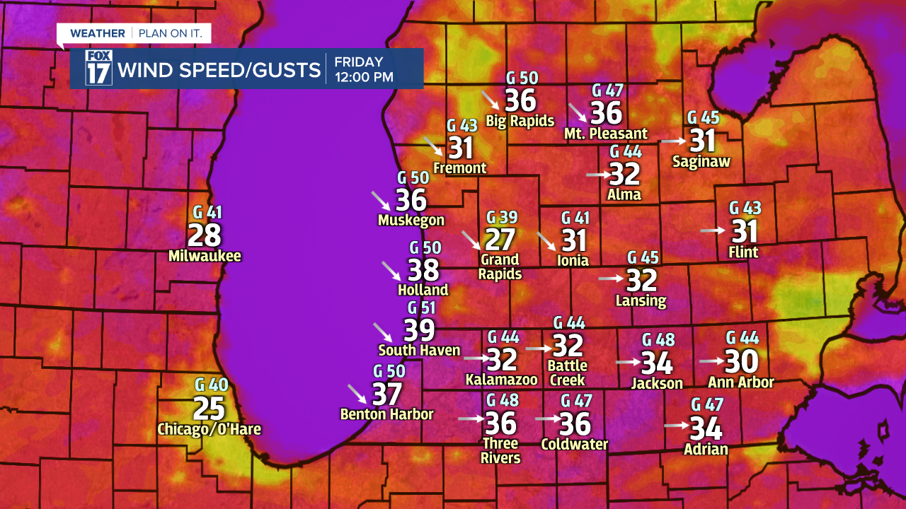
Bitter cold wind chills below zero will impact much of our area!
Sustained winds between 20 to 30 mph with gusts over 40 mph are likely, which will drive our well-below zero feels-like temperatures. The wind will additionally create the blowing and drifting snow, which will reduce visibility down to white-out conditions at times. These strong winds are likely to generate power outages as well.
You'll hear terms like winter storm, blizzard, bomb cyclone, and bombogenesis. The term winter storm signifies the possibility of heavy snow, while blizzard means very strong, driving winds, creating white-out conditions at times. The difference between the two deals more with visibility. Blizzard criteria means visibility of a quarter mile or less for more than three hours. we likely won't reach that threshold across our eastern counties. The term bomb cyclone simply means this storm system is expected to rapidly intensify as it tracks into the Great Lakes and Canada and drop 24 millibars of pressure (or more) within a 24 hour period.
Our entire FOX 17 team of Meteorologists will be tracking this system into and through the state this weekend. Make sure to stay up on later forecasts! Get the latest at www.fox17online.com/weather.
