


WEST MICHIGAN — When temperatures start to dip in the winter, and precipitation begins to fall, West Michigan communities tend to see snow. However, there have been a few days in the forecast that call for a 'rain / snow mix.' But what does that mean?
There are multiple types of precipitation. They include rain, freezing rain, sleet and snow.

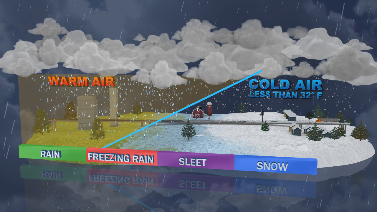
Rain happens when warm air is consistent from the clouds all the way to the ground, or surface level.
Things start getting tricky when we add different temperatures to different layers of the air.
According to the National Weather Service and the National Oceanic and Atmospheric Administration, the different types of mixed precipitation are as follows;
Freezing rain occurs when snowflakes descend into a warmer layer of air and melt completely. When these liquid water drops fall through another thin layer of freezing air just above the surface, they don't have enough time to refreeze before reaching the ground. Because they are “supercooled,” they instantly refreeze upon contact with anything that that is at or below freezing (32 degrees F), creating a glaze of ice on the ground, trees, power lines, or other objects. Even light accumulations can cause dangerous travel, while heavier amounts can cause significant damage to trees and power lines. A significant accumulation of freezing rain lasting several hours or more is called an ice storm.

Sleet occurs when snowflakes only partially melt when they fall through a shallow layer of warm air. These slushy drops refreeze as they next fall through a deep layer of freezing air above the surface, and eventually reach the ground as frozen rain drops that bounce on impact. Depending on the intensity and duration, sleet can accumulate on the ground much like snow.

Snow Most precipitation that forms in wintertime clouds starts out as snow because the top layer of the storm is usually cold enough to create snowflakes. Snowflakes are just collections of ice crystals that cling to each other as they fall toward the ground. Precipitation continues to fall as snow when the temperature remains at or below 32 degrees F from the cloud base to the ground.


While all of the types of precipitation can be dangerous, it's especially important to stay vigilant when it comes to Black Ice. This can form when precipitation freezes to the road, and it looks like either a wet patch, or can't be seen.

It's important to also keep in mind that when winter driving conditions change, you'll have to change your braking habits too.
Three-quarters of the way through our region’s first seasonal snowfall, roads around MKE County are slick. MCSO encourages you to consider the tips in this graphic RE: safe braking distances in winter inclement weather vs. other conditions: pic.twitter.com/bqUqSBQH9Z
— Milwaukee County Sheriff's Office (@MilwCoSheriff) November 1, 2023
Stay up to date with the latest forecasts with FOX 17 Meteorologists.
