


WEST MICHIGAN — The beginning of February 2024 will go down in the record books as the warmest and least snowy start to February in recorded history for West Michigan. That's according to data archived within the National Weather Service data base.
Temperatures have been above-average every single day in February so far. The average high temperature for the first two weeks of February ranges between 31 to 33 degrees. Below is a breakdown of the reported high temperatures in Grand Rapids. Three days within the last eleven have produced high temperatures in the 50s.

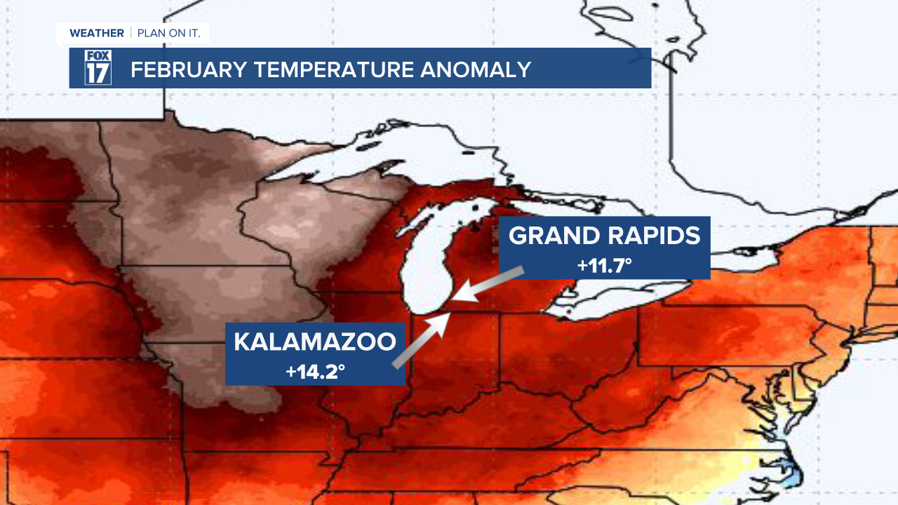
Based on climatology, West Michigan has been well-above average for this time of year. Grand Rapids is 11.7 degrees above a typical start to February, with Kalamazoo coming in at 14.2 degrees above average.
When it comes to snow, we're well-below average for most of the state of Michigan. Here's a look at how much snow depth we have as of February 12. There is snow on the ground in Northern Michigan, primarily in the Upper Peninsula.

Based on climatology, West Michigan typically has a decent snow pack during the middle of winter. Below is a breakdown of days with at least one inch of snow depth through February 12.
Within the 2023-2024 winter season, West Michigan has seen 19 days with at least one inch of snow depth. That is the least amount of days with snow on the ground since the 1982-1983 winter season. Last season (2022-2023), West Michigan had 37 days with at least one inch of snow depth by February 12. Last season ended up having 54 days total with at least one inch of snow depth.

On average, West Michigan normally sees 53 days of at least one inch of snow within the winter season by February 12. That is the average between 1991 and 2020.
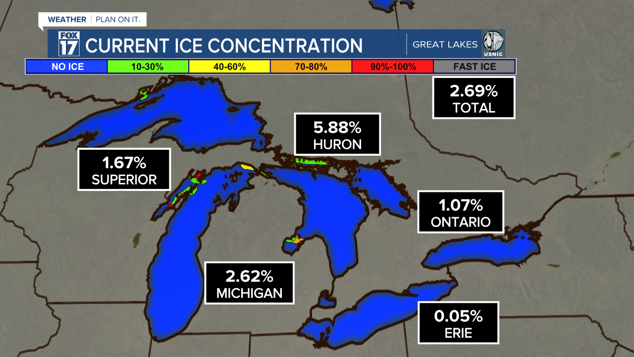
In addition to the lack of snow, the limited blasts of cold air have also resulted in the least amount of ice concentration for Lake Michigan during the beginning of February. As of February 12, Lake Michigan only has 2.62 percent of ice coverage.
On average, Lake Michigan ranges between about 10 to 25 percent of ice coverage during the beginning of February. This map is from NOAA Coast Watch Great Lakes, representing data from 1973 to 2024.
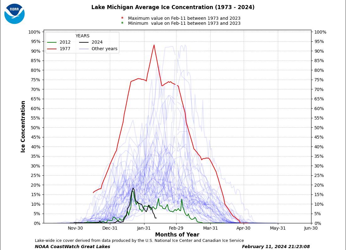
The red line represents the ice concentration of Lake Michigan during the year 1977, showing one of the highest ice concentration years in recorded history. The green line represents the ice concentration during the year 2012, which is a year that had historically low ice. The black line represents this year, 2024. We're currently experiencing the lowest amount of ice concentration for the beginning of February in recorded history.
Accumulating snow and cooler temperatures are expected to return to West Michigan this upcoming week. Stay alert with the FOX 17 Weather Team for all updates.
