


The forecast from FOX 17 Weather Ready Meteorologist Colton Cichoracki: A big warming trend is underway! After a warmer, sunny day today, even warmer air moves in this weekend as temperatures climb into the 80s. Clouds will slowly filter in tonight with lows in the 40s. On Friday, a stray shower or storm is possible early but we will dry out in the afternoon. Highs will be near 70 degrees. Over the weekend, temperatures will reach the upper 70s to lower 80s. Unsettled weather is expected beginning Saturday and lasting into early next week with rounds of showers and storms, especially for Sunday and Monday. There will be the potential for some strong thunderstorms in West Michigan as well, especially on Monday. Something we will keep a close eye on in the days to come. Mild air will continue to be around into next week with chances for showers lingering as well.
TONIGHT: Clear this evening, becoming partly cloudy overnight. Lows in the lower 40s. Winds light/variable.
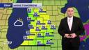
FRIDAY: Morning clouds...maybe a light shower or two, otherwise partly cloudy to partly sunny and mild. Highs around 70. Winds south at 10 to 15 mph.
SATURDAY: Partly cloudy to partly sunny and warm. Chance of a shower/storm. Highs around 80.
SUNDAY: Partly cloudy to partly sunny and warm. Chance of showers and thunderstorms. Highs around 80.
MONDAY: Partly cloudy to partly sunny and hot. Thunderstorms likely, especially in the afternoon and evening. Some may be strong to severe. Highs in the mid/upper 80s. Likely the warmest day of the year so far!
TUESDAY: Mostly cloudy and warm with a few showers. Chance of thunderstorms. Highs around 80.
WEDNESDAY: Mostly cloudy with a few showers. Highs in the 70s.
THURSDAY: Partly cloudy. Highs in the upper 60s.
Want alerts when inconvenient or severe weather is headed your way? Download the FOX 17 Weather app and set up notifications for where you live.
For the latest details on the weather in West Michigan, head to the FOX 17 Weather page.
Follow FOX 17: Facebook - X (formerly Twitter) - Instagram - YouTube
