
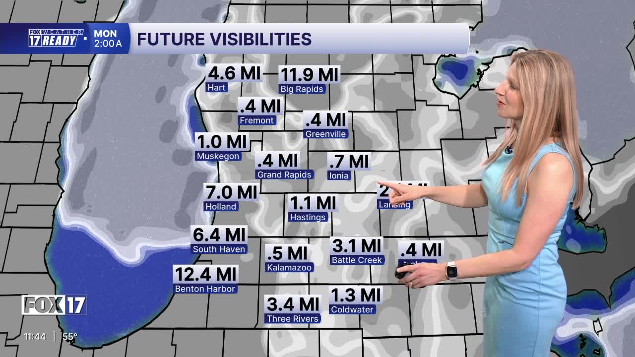


WEST MICHIGAN — The forecast from FOX 17 Weather Ready Meteorologist Kara James: Dense fog is expected overnight across West Michigan, and the entire area is under a DENSE FOG ADVISORY until 11 a.m. Monday. Widespread visibility less than half a mile is expected through the early to mid morning. Drive carefully! Lows drop into the low 50s overnight, with light wind. Fog will slowly lift into the mid morning Memorial Day before burning off and leading into a very warm and mostly sunny day with highs in the 80s! Due to the lighter winds Memorial Day, wave heights on Lake Michigan will be low, less than 1 foot. However, water temperatures are still dangerously cold in the 40s and 50s. Mainly quiet and warm weather is expected through the upcoming week, with our only rain chance coming on Wednesday. Temperatures will remain above average with highs in the 80s Tuesday and Wednesday, and 70s Thursday through the weekend. Happy unofficial start of summer!
TONIGHT: DENSE FOG ADVISORY. Partly cloudy, lows in the lower 50s. Winds W/SW at 5 mph.
MEMORIAL DAY: Morning fog, clearing early. Mostly sunny and warm. Highs in the low 80s. Great outdoor weather!
TUESDAY: Mostly sunny and warmer. Highs in the low/mid 80s.
WEDNESDAY: Partly cloudy, chance of showers. Highs in the low 80s.
THURSDAY: Mostly sunny. Highs in the upper 70s.
FRIDAY: Partly cloudy. Highs in the upper 70s.
SATURDAY: Partly cloudy. Highs in the upper 70s.
SUNDAY: Partly cloudy. Highs in the mid 70s.
Want alerts when inconvenient or severe weather is headed your way? Download the FOX 17 Weather app and set up notifications for where you live.
For the latest details on the weather in West Michigan, head to the FOX 17 Weather page.
Follow FOX 17: Facebook - X (formerly Twitter) - Instagram - YouTube
