


The forecast from FOX 17 Weather Ready Chief Meteorologist Reece Cole: A cold front and low pressure moving east is bringing a relief from the humidity to start the weekend! Look for cooler, less humid conditions Saturday, but more heat and humidity arrive on Sunday with highs around 90. Early indications show a warm, but potentially stormy 4th of July. Stay tuned to the FOX 17 Weather Ready Team for your latest forecast updates.
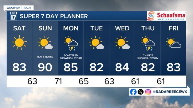
TONIGHT: Chance of an early evening shower/storm, otherwise partly cloudy. Lows in the low/mid 60s. Winds west at 5 to 10 mph.
SATURDAY: Mostly sunny to partly cloudy and less humid. Highs in the lower 80s. Winds northwest/west at 5 to 10 mph.
SUNDAY: Mostly sunny and hot. Slight chance of a shower/storm as a warm front lifts into the state. Highs around 90 with feels like temps in the mid 90s.
MONDAY: Partly sunny, warm, and muggy. Chance of isolated storms. Highs in the mid 80s.
TUESDAY: Mostly sunny and pleasant. Highs in the low/mid 80s.
WEDNESDAY: Mostly sunny and pleasant. Highs in the mid 80s.
For the latest details on the weather in West Michigan, head to the FOX 17 Weather page.
Follow FOX 17: Facebook - X (formerly Twitter) - Instagram - YouTube
