
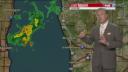


WEST MICHIGAN — WEST MICHIGAN — The forecast from FOX 17 Chief Meteorologist Kevin Craig: Low pressure in the upper levels of the atmosphere will remain to our north in Canada through Thursday. This will act to maintain an overall northwest flow aloft, which will keep slightly cooler air in place across the FOX 17 viewing area with highs in the 70s. Warmer temperatures and more humidity will return by Friday with rain and thunderstorm chances increasing by Friday evening. Some may be strong to severe with hail and wind as the primary threats.
TONIGHT: An isolated shower or thundershower is possible early overnight along our lakeshore communities, other partly cloudy skies. Lows in the mid/upper 50s. West/southwest winds at 5 to 15 mph becoming light.
THURSDAY/TOMORROW: Partly cloudy to partly sunny and pleasant. An isolated afternoon shower is possible south of Grand Rapids. Highs in the upper 70s to near 80. West-southwest winds at 7 to 14 mph.
TOMORROW NIGHT: Mostly clear and mild. Lows around 60°. Light south/southwest wind.
FRIDAY: Mostly sunny during the morning, followed by increasing afternoon clouds. A chance of thunderstorms by evening. Breezy, warm, and humid with highs in the middle 80s. Southwest winds at 10 to 20 mph. Some of these storms may be on the strong to severe side with heavy rain, dangerous lightning, large hail, and damaging winds.
