


The forecast from FOX 17 Weather Ready Meteorologist Kara James: A big warming trend is underway! Highs will reach into the 80s Saturday through early next week, but that comes with chances for thunderstorms as well. The first chance for rain and thunderstorms will be in the early morning Saturday. Most of the day will be dry once the morning rain and storms passes through, with highs aruond 80. Another round of showers and storms is possible Sunday as a warm front lifts through, which will also usher in more humid air. Crank up those air conditioners! Highs Sunday and Monday will be in the low to mid 80s, feeling even hotter due to increasing humidity. The best chance for strong to severe thunderstorms in West Michigan is Monday evening, and we are already highlighted in a Slight Risk (Level 2 out of 5). We will continue to track the heat, humidity, and storm possibilities the next several days. Cooler air returns by the middle of next week with highs in the mid/upper 60s, slightly below avereage.
TONIGHT: Becoming mostly cloudy overnight with the chance of showers late. Lows in the mid 50s. Winds south at 5 to 15 mph.
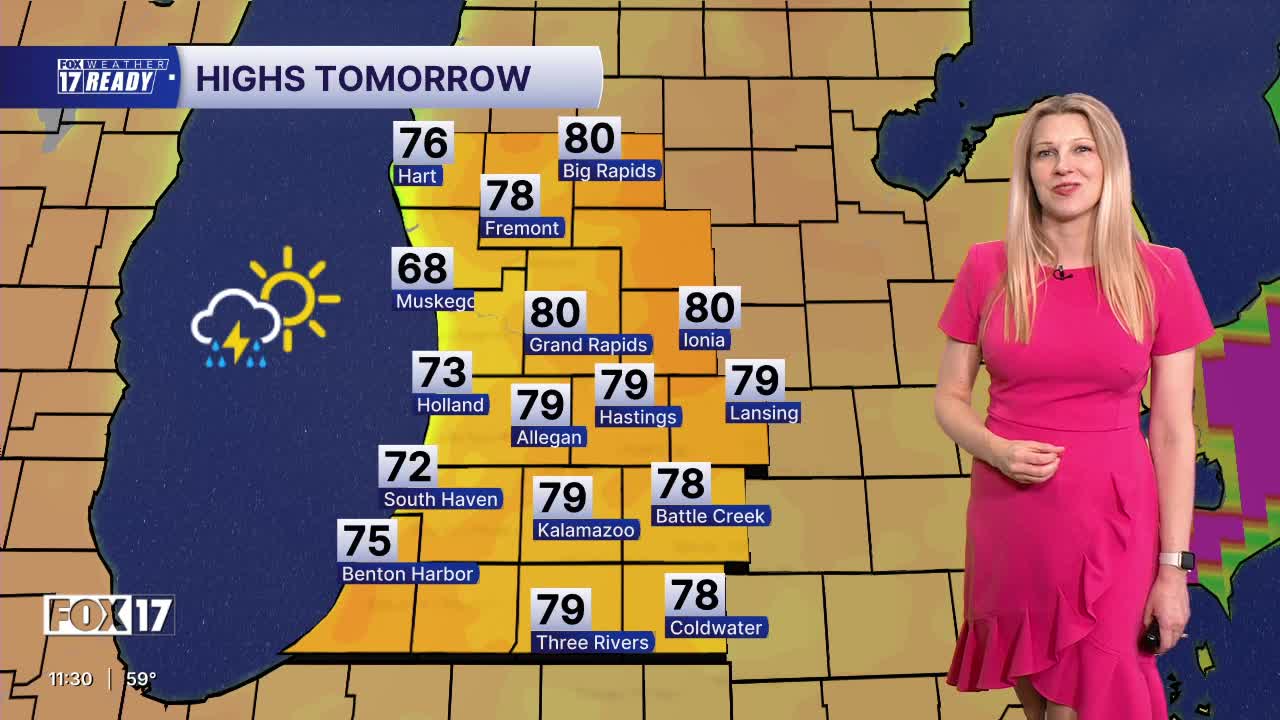
SATURDAY: Chance of morning showers/storms, otherwise partly sunny and warm. Chance of a P.M. shower/storm. Highs around 80. Winds southwest at 10 to 15 mph.
SUNDAY: Partly partly sunny, warm, and more humid. A few showers and thunderstorms possible. Highs in the lower 80s.
MONDAY: Partly cloudy, hot, and humid. Thunderstorms likely, especially in the afternoon and evening. Some may be strong to severe. Highs in the mid/upper 80s. Some locations may hit their first 90! Likely the warmest day of the year so far!
TUESDAY: Mostly cloudy and warm with a few showers. Chance of thunderstorms. Highs in the lower 80s.
WEDNESDAY: Morning clouds and showers, afternoon sunshine, cooler. Highs in mid/upper 60s.
THURSDAY: Mostly sunny to partly cloudy and cool. Highs in the upper 60s.
FRIDAY: Partly cloudy with highs in the mid 60s.
Want alerts when inconvenient or severe weather is headed your way? Download the FOX 17 Weather app and set up notifications for where you live.
For the latest details on the weather in West Michigan, head to the FOX 17 Weather page.
Follow FOX 17: Facebook - X (formerly Twitter) - Instagram - YouTube
