


WEST MICHIGAN — The coldest air of the season thus far starts to settle in for the weekend! Lows Sunday morning will be in the teens. High temperatures on Sunday will only be in the middle to upper 20s. Overnight low temperatures crash into the teens! Feels like temps all day will be in the single digits or teens as well.
When factoring in the persistent and strong winds, get ready for some bitter cold feels-like temperatures! Many of the feels-like temperatures will be in the single digits over the weekend. Note the big upper level trough or dip in our jet stream this weekend with the colder tones or air over the Great Lakes.

With cold temperatures at nearly all layers of the atmosphere and persistent winds from the west, the lake effect "snow machine" remains fired up over the weekend! Get your sleds and snow gear ready as we expect this to be a shovel-able and plow-able snow for many of us! The heaviest snow accumulation will likely be along and west of U.S. 131. However, with persistent winds from the west, accumulation will develop east of U.S. 131. As of 5 p.m. Saturday, over 18 inches of snow has fallen at the Grand Rapids Airport. The latest alerts have been canceled, as snow begins to taper off early Sunday morning. Dry air moves in, cutting off moisture to the region.
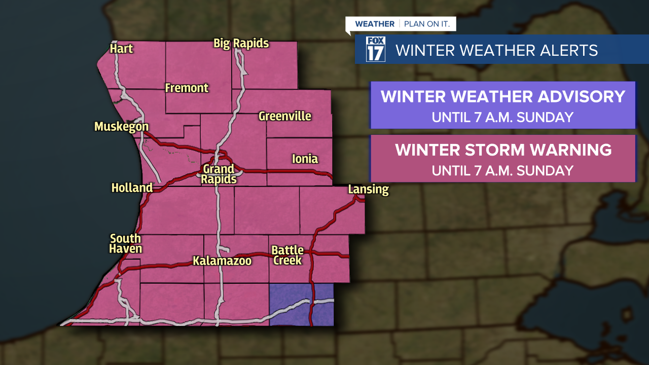
A WINTER STORM WARNING is in effect until 7 a.m. Sunday for Ottawa, Allegan, Van Buren, Kent, Ionia, Barry, Eaton, Kalamazoo, and Calhoun counties. An additional 7" to 10" of snow accumulation will be possible by Sunday morning for those counties, with wind gusts up to 40 mph. Isolated higher amounts are possible, especially along the U.S. 131 corridor between Grand Rapids and Kalamazoo.
A WINTER STORM WARNING is in effect until 7 a.m. Sunday for Oceana, Muskegon, Newaygo, Mecosta, and Montcalm counties, where an additional 5" to 8" will be possible.
A WINTER STORM WARNING is in effect until 7 a.m. Sunday for Berrien, Cass and St. Joseph counties, where an additional 4" to 7" will be possible.
A WINTER WEATHER ADVISORY is in effect until 7 a.m. Sunday for Branch county, where an additional 2" to 5" will be possible.
After looking at several different forecast models and taking into consideration moisture, temperature, and the presence of extreme instability, our forecast predictions are below from Friday through Sunday. Some areas may see double digit totals. We believe the best chance at seeing a foot or more of snow will occur from Grand Rapids to Kalamazoo along the U.S. 131 corridor and about 10 to 15 miles east and west of it. Note the bullseye on the image below. In this particular lake effect event, the heaviest will not necessarily occur at the immediate lake shore as strong westerly winds drag in further inland.

Keep in mind for lake effect snow, there must be at least a 13 degree Celsius temperature difference between the air traveling across the lake about 5,000 feet above the surface and the water temperature of the Great Lakes. We'll have about a 25 degree difference producing extreme instability! This is a great indicator for the FOX 17 Weather Team that heavy lake effect snow is likely.

All-in-all, don't forget your winter gear this weekend! Hats and gloves will be needed each day. You'll also want to take it easy on the roadways! With overnight low temperatures falling to the teens and 20s, slick roads are anticipated early in the morning and late at night when temperatures are the coldest. For your latest forecast, visit: www.FOX17Online.com/weather/.
