

WEST MICHIGAN — Southwest Lower Michigan remains in an "ENHANCED" risk for severe weather late this afternoon and into the evening. Other parts of our viewing audience are in a "SLIGHT" risk. See the map below. These threats were elevated quickly early Monday afternoon as a derecho began forming over Iowa and tracking eastward over northern Illinois producing between 70 and 100 mph winds.
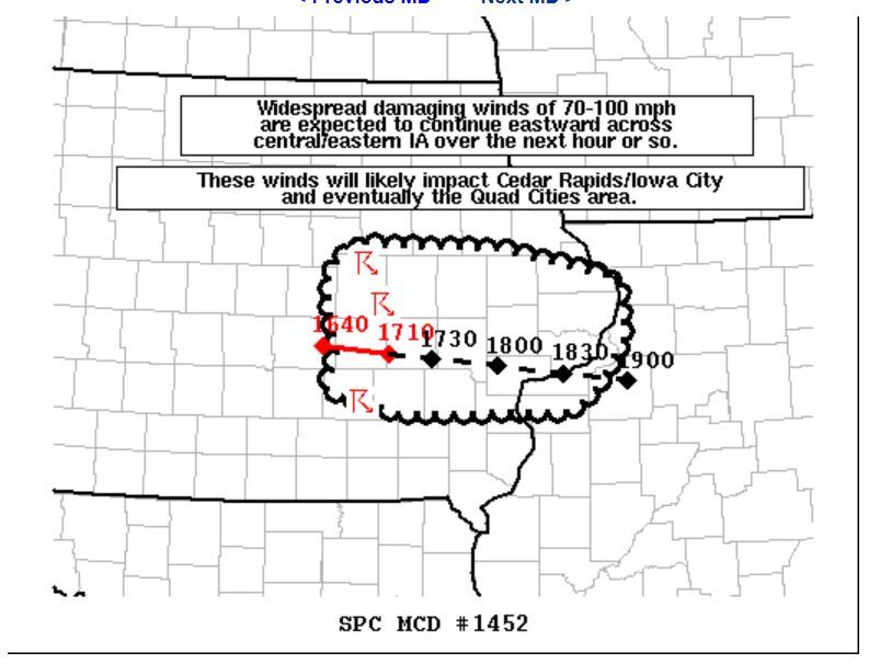
Recall that a derecho is well defined line of very strong to severe storms with intense winds that typically can move over long distances. We had such an event in 1998. Again, these are characterized by strong, damaging straight line winds. See the image below issued this afternoon from The Storm Prediction Center.
While it remains questionable whether this derecho can remain intact and affect West Michigan, other individual thunderstorm cells may form separate from the derecho and generate severe thunderstorm warnings, damaging straight line winds, and perhaps some isolated large hail. See images below from our forecast model valid at 6 P.M. and again and 8 P.M.
SEVERE THUNDERSTORM WATCHES have already been issued from the U.P. of Michigan, through Green Bay, Milwaukee, Chicago, and all the way south to almost Champaign , Illinois. The scope of this system is huge and is potentially affecting millions, although the severe derecho winds affect a much smaller defined area. Most of West Michigan remains under a SEVERE THUNDESTORM WATCH throguh midnight...areas in pink. That means conditions are favorable for the development of strong to severe storms...including damaging winds, large hail, heavy rain, even an isolated tornado. See image below.
Below are the possible severe weather threats we could see in West Michigan from these storms. Up to golf ball size hail around 1.5 inches. Winds up to 75 mph, but likely only around 60 with individual storm cells. And to a lesser degree, and isolated tornado. That said, we are also concerned about the possibility of a meteotsunami. Lake Michigan experienced one of these on April 13, 2018 around Ludington. They are indeed rare, but they do happen. Water levels in Ludington rose about a foot an a half! A meteotsunami is a large wave (or waves) driven by air pressure drops and disturbances associated with fast moving strong to severe thunderstorms, squalls, derechos, or fronts. The storm generates a wave that moves towards the shore, and is amplified by a shallow continental shelf and inlet, bay, or other coastal feature. With an approaching derecho from Illinois, our biggest concern is the possibility of this occurring from South Haven southward at/on the beaches. Please exercise caution in these areas today.
Make sure to keep an eye to the sky and have multiple ways to receive severe weather warnings and information either from our FOX 17 mobile weather APP, www.fox17online.com/weather, or from a NOAA weather radio.
