


WEST MICHIGAN — Weather models are in agreement, you'll have a blue Christmas if you're a fan of snow! It'll look more like a 'green' Christmas not only on the radar, but on the ground with the lack of snowfall. Temperatures are expected to be too warm this year for snow, with highs topping the lower and mid 50s.
Are you planning to travel for the holidays? Below is a breakdown of the timing of rain, anticipated temperatures, wind gust potential, and an extended outlook.
Timing of Rain for Christmas Eve and Christmas Day
You will not need your winter jacket or gloves this Christmas Eve or Christmas Day. Instead, you'll need your rain coat and umbrella. A system is set to develop in Iowa, Illinois, and Wisconsin on Christmas Eve.

A stray sprinkle is possible in Michigan on Christmas Eve, however most of the state will remain dry with cloudy skies.
Showers are likely to trickle into West Michigan on Christmas Day. By 7 a.m. Monday, West Michigan will wake up to cloudy skies.

As you're opening presents Christmas morning, most of West Michigan will be dry and cloudy. Widespread rain will push into the region in the afternoon on Christmas Day, arriving from the southwest. Below is the anticipated radar by 2 p.m. Monday.

Showers will remain widespread over the state for Christmas Day. With damp roads and the potential for strong winds on Christmas Day, you'll want to take your time while traveling. Thankfully, temperatures will remain above freezing overnight. This limits our black ice potential.
Anticipated Temperatures
Talk about a wave of warmth! Temperatures will be well-above average for this upcoming Christmas Eve and Christmas Day. Christmas Day will be the warmest day of the week with a high of 55 degrees.

The heat on Christmas is not likely to break a record. The current record high temperature for Christmas is 65 degrees, set back in 1982.
Cooler air is likely to filter in to end next week, returning the chance for snow.
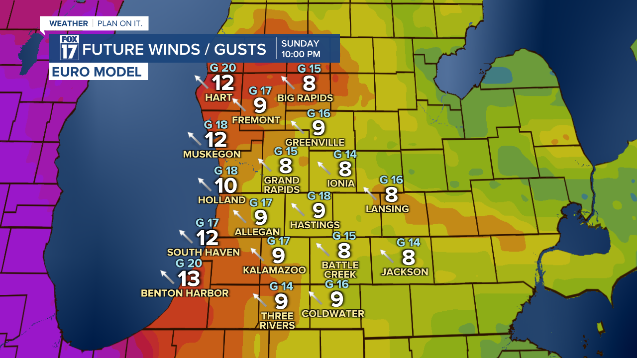
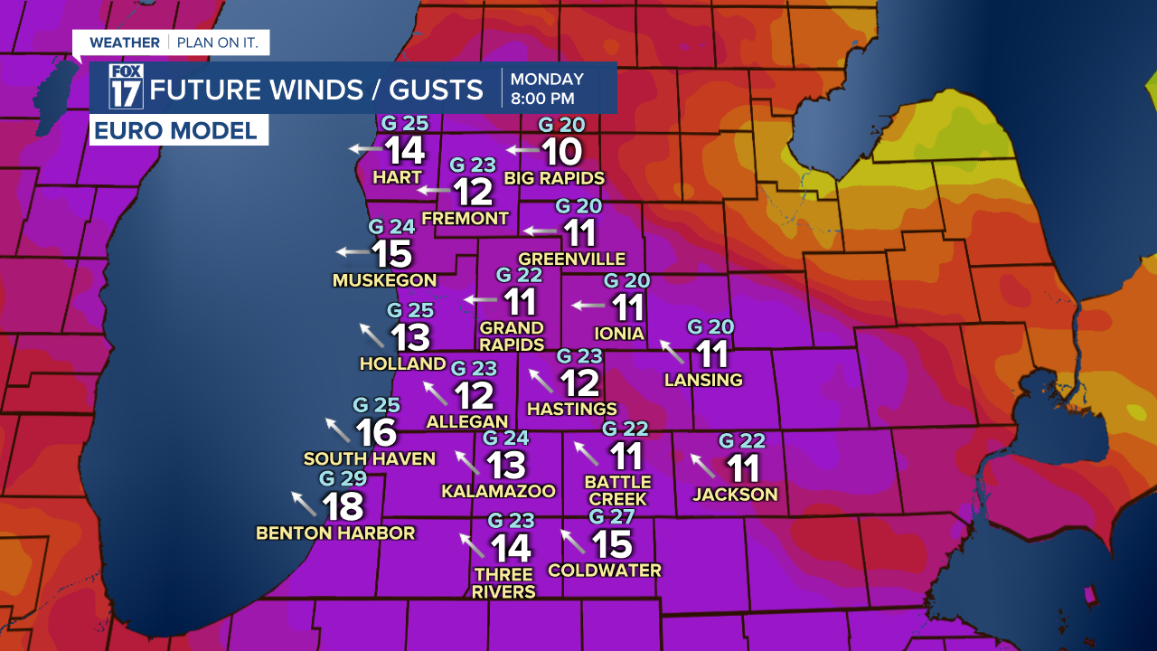
Wind Gust Potential
Hold down your outdoor Christmas decorations ahead of Christmas Day! Strong winds are likely to develop due to our approaching system.
Winds will pick up Christmas Eve night, which is Sunday. Winds will gust up to 20 mph on Sunday night from the southeast.
The strongest winds are likely on Christmas Day. Wind gusts will likely range over 30 mph on Christmas Day, which is Monday.
Extended Outlook
While we will not have a 'white' Christmas this year, snow is in the extended forecast! Our latest models indicate colder air wrapping into West Michigan starting on Wednesday.
Once the colder air sets in late Wednesday night and into Thursday, light rain is expected to transition over to snow.
Travel could be slick on Thursday as a wintry mix of rain and snow is possible at times.
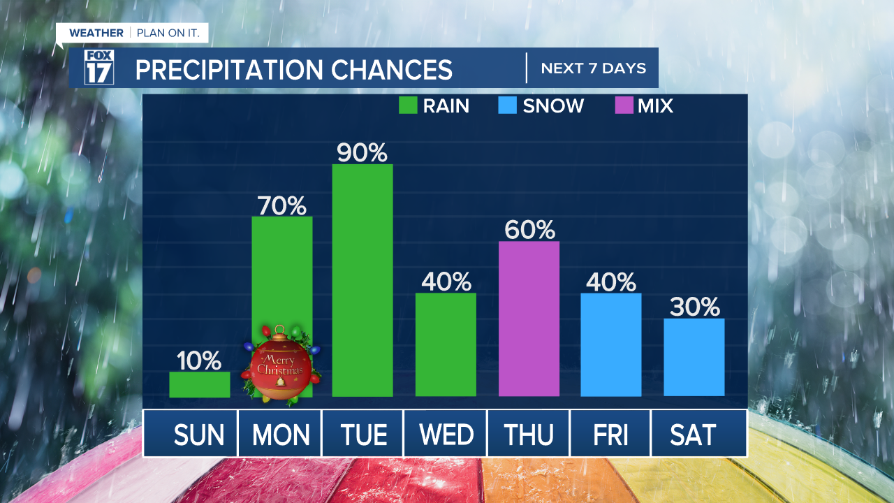
The best chance of a few snowflakes in the 7-day forecast is Friday and Saturday.
Stay alert with the FOX 17 Weather Team for your latest holiday forecast. You can download the updated FOX 17 News App for your own personal radar.
