


WEST MICHIGAN — Expect a mainly cloudy one for all sections of West Michigan this afternoon with temperatures remaining rather steady in the lower half of the 30s. A few flurries can be around this morning and early afternoon with the prospect for a little spotty drizzle to mix in as well. Nonetheless, nothing important is anticipated precipitation-wise for West Michigan today. Northwest winds will pick up just a bit this afternoon at 10-15 mph with the breeziest conditions along the immediate Lake Michigan shoreline with some gusts to 20-30 mph materializing as we along.
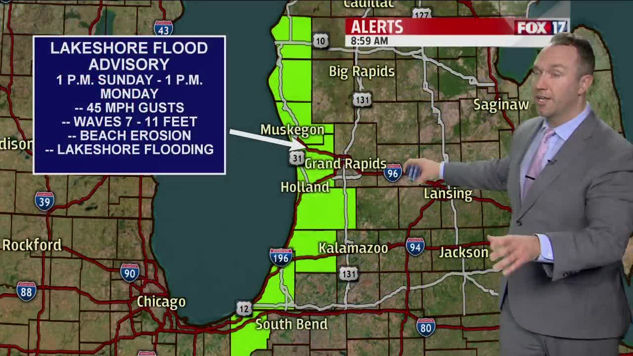
Mostly cloudy weather carries through this evening and overnight with lows around 30 degrees. Northwest winds relax tonight for inland locations to between 5-10 mph while continuing on the breezy side for immediate Lakeshore locations. We look for more clouds on Sunday along with winds ramping up as a clipper-like system passes to our north through southern Ontario. South winds at the start tomorrow shift to the southwest and then the west into the afternoon while increasing to 15-25 mph gusting to 30-40 mph. Lakeshore communities will feel the brunt of the winds gusting to around 45 mph or so on Sunday. A Lakeshore Flood Advisory goes into effect on Sunday at 1 P.M. and lasts until 1 P.M. Monday for all of our lakeshore counties. Waves are expected to build to between 7-11 feet. More beach erosion will occur and more low-lying flooding will be possible. A few light snow and/or rain showers will be possible mid-late morning into the afternoon but accumulations are not a concern. Temperatures rise into the mid to upper 30s to wrap up the weekend.
Monday brings quiet weather and even some sunshine for several hours. Clouds will increase through the afternoon and evening as our next system approaches for Tuesday. Highs on Monday will reach the upper 30s as west to southwest winds stay on the breezy side around 15 mph gusting to near 25 mph or so at times. Tuesday looks to offer up our best chance for some light accumulations of snow as a new system brings a return to light snow showers to West Michigan. This will not be a major weather event but some areas could see the ground get whitened. Temps head for the lower 30s on Tuesday.
Wednesday goes colder in the upper 20s with a few lake-effect flurries and snow showers expected mainly during the morning. Our attention then turns to a new system approaching from the southwest for Thursday afternoon into the first half of Friday. Winds shift back to the south in advance of this area of low pressure and temperatures head back for the lower 40s for both Thursday and Friday. Rain, and not snow, looks to be the main player the second half of Thursday into Friday. Somewhat colder air likely filters in behind this system for next weekend. The overall mild pattern we have seen recently shows no obvious signs of giving up the ghost over the next 7-10 days though some hints are showing up that a colder pattern could materialize at some point during the second half of this month.
