


MARSHALL, Mich. — The National Weather Service in Grand Rapids released a report on the Calhoun County tornado that occurred during the early morning hours of February 28. Their report features information about the tornado that touched down, a breakdown of the weather conditions leading up to the severe weather event, storm reports, and photos.

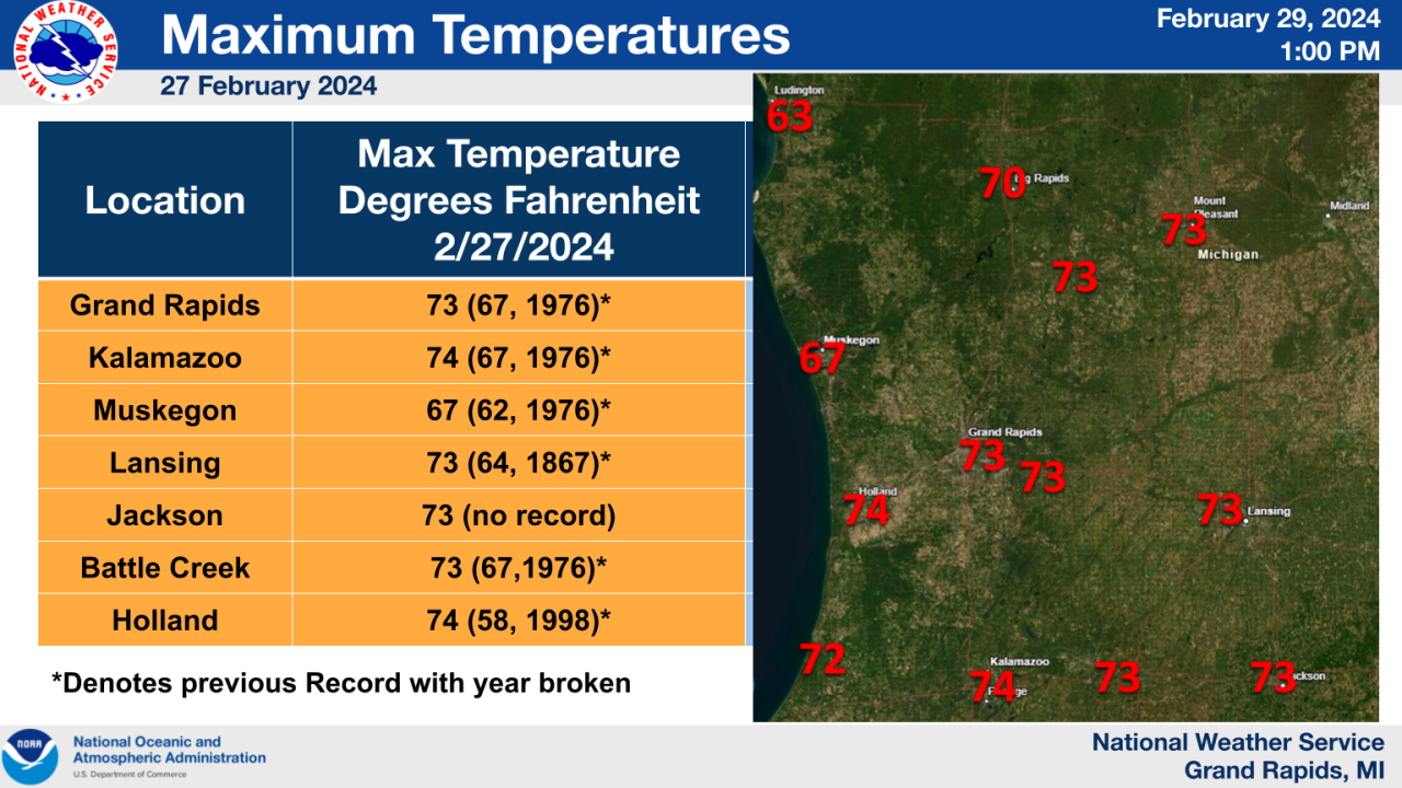
"February 27, 2024 will be remembered as an exceedingly warm day followed by rapid changes at night," stated the National Weather Service in their event overview. Tuesday, February 27 brought record temperatures to West Michigan. High temperatures in Grand Rapids hit 73 degrees, marking it as the warmest February day on record. According to the National Weather Service in Grand Rapids, their records go back 130 years.
That warm, moist air, in addition to other atmospheric elements, created ripe conditions for severe thunderstorms. You can see a complete breakdown of the atmospheric conditions in the National Weather Service's report.
"One long-lived supercell with a persistent mesocyclone caused damage along the I-94 corridor, which included an EF-1 tornado near Marshall, Michigan," stated the National Weather Service. "Along with this supercell, a line of storms brought upwards of 2.4 inch hail across Lower Michigan to areas south of I-96. This storm system continued eastward and caused an EF-2 tornado in Grand Blanc, Michigan."

As previously reported on FOX 17 News, the National Weather Service estimated the Calhoun County tornado to have peak wind speeds at 110 mph. That equates to a high-end EF-1 tornado. An EF-2 tornado indicates peak wind speeds between 111 to 135 mph.
The Calhoun County tornado traveled through Marshall, touching down just east of I-69 and north of I-94. The tornado touched down near 16 1/2 Mile Road, eventually traveling northeast to the vicinity of 21 1/2 Mile Road and L Drive North.
According to the National Weather Service, hundreds of trees were snapped or uprooted along the path. There was also damage to nearby buildings and homes.

The supercell also produced large hail. The largest reported hail was 2.5 inches in diameter at Brownlee Park, which is the size of a tennis ball.

For the complete report, click here.
