


GRAND RAPIDS, Mich. — Lake Michigan water levels have been a major problem for a few years now, and anyone that lives on or near our lakeshore knows first-hand how bad this problem is.
Last year we had high record-breaking Lake Michigan water levels, and now at this point of the year Lake Michigan water levels have dropped by more than a foot. City officials are still on high alert and know they are not in the clear.
A problem years in the making that will take years to fix, plus millions of dollars in repairs. Lake Michigan, which so many Michiganders love, continues to cause devastating coastal erosion. Deanna Apps with the US Army Corps of Engineers says last year Lake Michigan and Lake Huron set record high water levels January through August, but this year we have seen water levels drop.
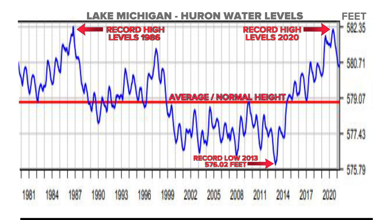
If we go in depth, we find that Lake Michigan water levels were down about 14 inches below last April’s monthly mean but still above averageby 22 inches from for normal April water levels. Now in May, water levels have continued to drop 4 more inches, and overall they are still 18 inches above normal levels. In other words, we aren’t out of the woods yet, and erosion damage can still be done.
"The risk for that those that coastal impact of shoreline, erosion, and flooding is definitely less," says Deanna Apps, Detroit district US Army Corps of Engineers physical scientist, "but it's still possible, especially as if we get an active storm or that moves through and we see large winds, and that could cause some increased wave action."
Numerous lake shore communities continue to battle the elements causing the erosion damage. Homeowners living on the edge of bluffs with their homes nearly falling into Lake Michigan or cities such as South Haven trying everything to save what they can. South Haven alone has had flooding in their wastewater treatment plant, closed some roads for almost a year, and added barriers to protect the South Beach underground reservoir.
The city of South Haven plans to leave all mitigation measures in place in fear of the water rising again. The Great Lakes have natural water cycles, according to the Army Corps of Engineers. Typically we see a springtime rise with extra rainfall and runoff, then peaking in the summer months, and finally a seasonal decline in the fall and winter with increased evaporation. City officials in South Haven estimate last year’s record high water level damage would cost millions, but these lake shore communities need help with the bills. Spending that much money in one year would basically cause a city to shut down with no leftover funds.
Lake Michigan water levels changing is nothing new. As many Michiganders likely recall the last time, we had high water levels back in 1986. This most recent spike though was a quick drastic change as we went from record low levels in 2013 to record high in 2020 making that just a 7 year turn around.
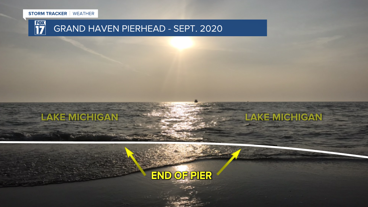
Recall that just a few months ago in September 2020, water was consistently topping the end of the pier in Grand Haven. The end of the pier was underwater regularly in 2020. See photo below.
We should also note that for many years prior to high water levels, you could walk along the waters edge on the beach in Grand Haven, navigate around the huge rocks/boulders, and access the pier without getting wet. Now, those rocks/boulders are underwater (and have been for a while). There is no longer access to the Grand Haven pier from the beach without getting wet, unless you go toward the campground and walk around the rocks that way. Long story short, about 50 yards or so of the beach itself has been lost to high water. See image below. Photo was taken last week.
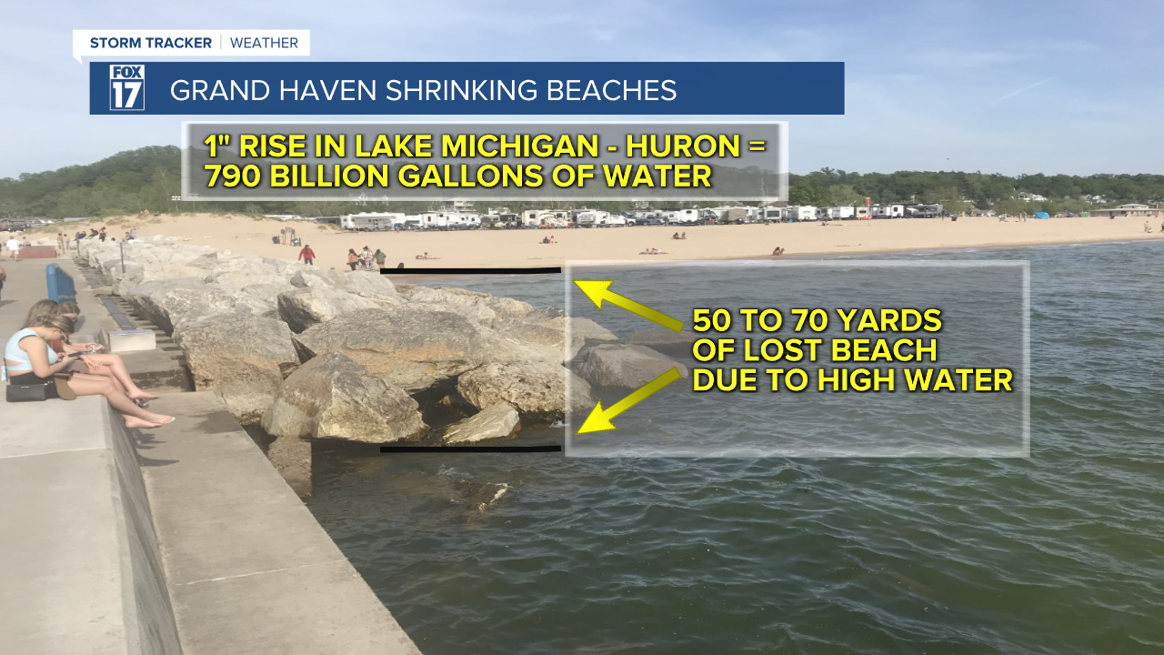
It's interesting to note that a one inch rise in the Lake Michigan - Huron basin equals 790 billion gallons of water! Remember that the Lake Michigan and Lake Huron basins are connected by the Straights of Mackinac and are considered one basin.
While the water level on Lake Michigan may be down about 18 inches from this time last year, that level is more noticeable at the end of the pier. Below is another photo that was snapped just last week. Take a look at the black lines below, where it becomes clearly visible the impact of levels being down a foot and a half. That part of the pier was also commonly underwater recently, but has since become passable again. Keep in mind, the Army Corps of Engineers expects a two inch rise in the level on Lake Michigan by the end of June due to spring rain/storms.

