


WEST MICHIGAN - Another storm system moving out of the Central Plains and into the Great Lakes tomorrow will bring us the chance at seeing some icing issues tonight into early Wednesday morning. WINTER WEATHER ADVISORIES have already been posted for parts of our FOX 17 viewing areas for this event. The chance at seeing .10" to .25" of ice accumulation is possible, mainly from Grand Rapids to the north and east toward Lansing and Detroit.
The image below shows the ADVISORIES in effect from 8 P.M. this evening through 10 A.M. Wednesday. This is meant to bring a heightened awareness to all of us that icing is possible during these hours. Extra time for travel at a much slower pace is advised.

Our northern counties of Oceana, Newaygo, Mecosta, and Montcalm have the advisories in effect from 10 P.M. this evening through noon Wednesday. These areas have the highest probability of seeing up to one quarter of an inch of ice accumulation into Wednesday morning. Counties not under the advisory will likely only see rain and perhaps a thundershower or two. We expect temperatures to warm quickly on Wednesday morning limiting any significant ice accumulations and widespread power outage issues. More rain showers and thundershowers are likely on Wednesday along with breezy conditions and temperatures reaching the upper 50s in/around Grand Rapids, to lower/mid 60s along the I-94 corridor.
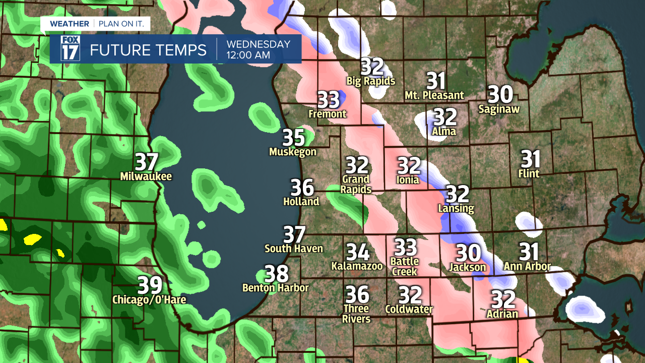
Below is an image from our forecast model valid for midnight tonight. The green is rain, the pink is freezing rain and sleet. Yellow/orange areas denote steadier/heavier rain pockets with rumbles of thunder possible.
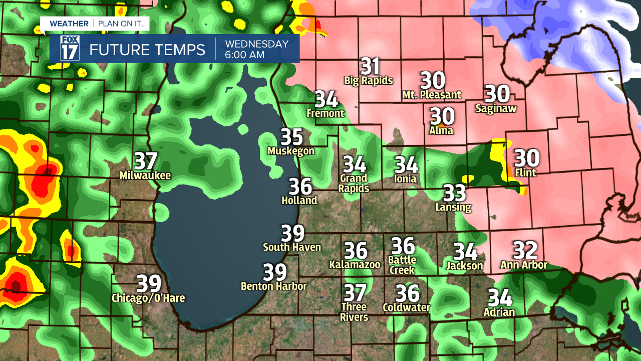
The next image below shows our forecast model at 6 A.M. Wednesday morning. As temperatures gradually warm, any icing will likely be confined to areas north/east of Grand Rapids. Most of the viewing area should be seeing a changeover to just plain rain.
Total rainfall with this system is expected to be in the range of between an inch and inch and a half through Thursday. Our warmest temperatures on Thursday will occur just after midnight in the mid/upper 50s, then fall into the 40s through the day. Lingering rain showers Thursday morning may mix with and changeover to snow showers later in the day with little/no accumulation. See image below.

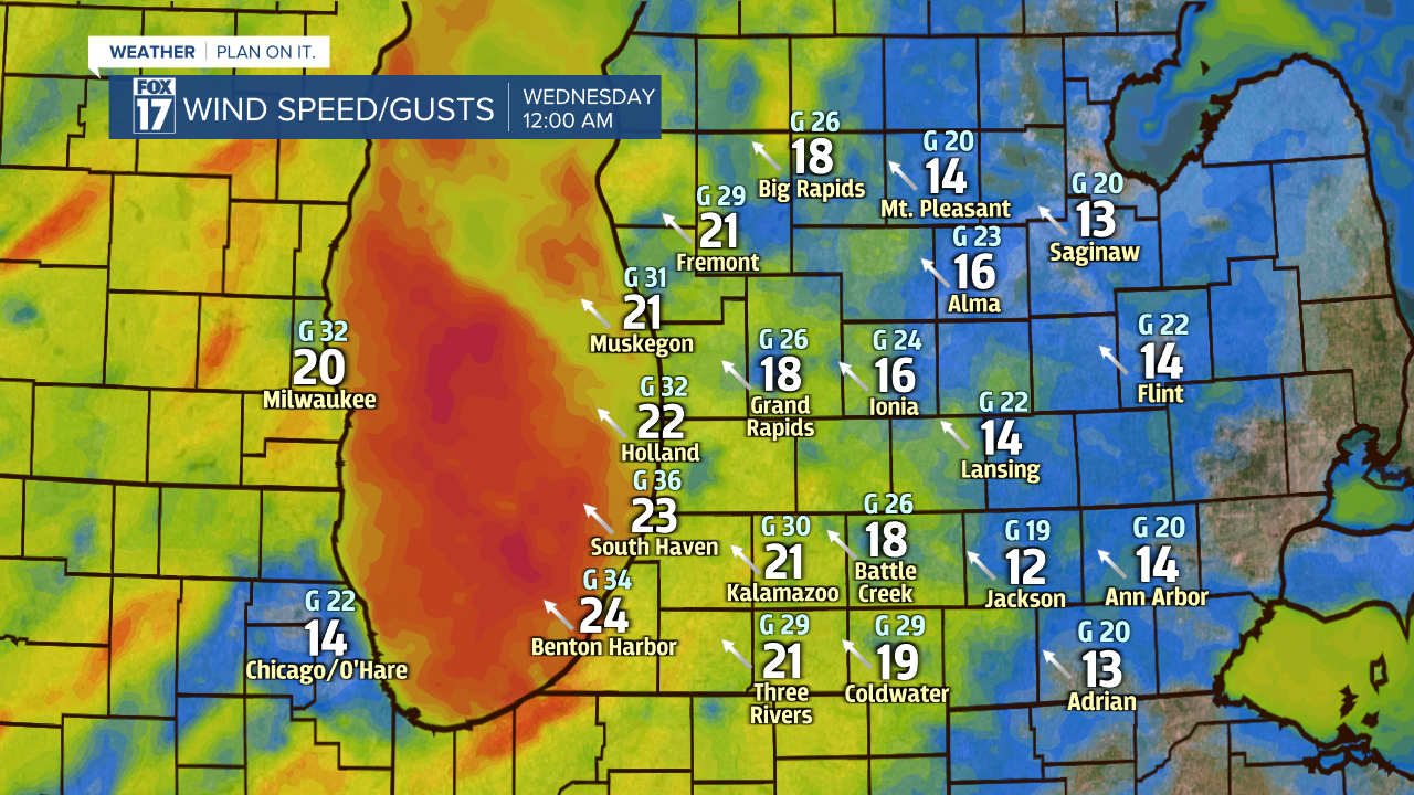
Wind will be another factor on Wednesday and Thursday as this low pressure system lifts through the Great Lakes. The image below shows wind speeds valid at midnight tonight. The larger, whiter number are wind speeds sustained , while the "G" number represent the wind gusts. The arrow represents the direction from which the wind is coming from.
Another look at wind speeds below, valid for 6 A.M. Wednesday. Still somewhat brisk!

We may see a changeover to snow showers through the day on Thursday behind this system with windy conditions and falling temperatures. Little/no accumulation is expected. Get the complete West Michigan forecast at www.fox17online.com/weather.
