
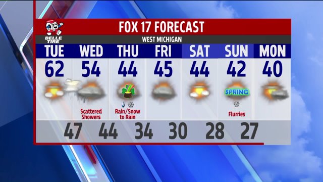

WEST MICHIGAN- It’s been a while since we’ve had a few thunderstorms roll into West Michigan, but that streak looks to end tonight as we’re expecting widespread thunderstorms, with even a few severe storms possible.

The National Weather Service Storm Prediction Center (SPC) has extended the “Slight” risk to include Kalamazoo and Grand Rapids among other areas not included in yesterday’s forecast. This means the likelihood for severe weather in these neighborhoods is increased.

A complex of thunderstorms southeast of Chicago will eventually turn into light evening rain for a few, but the widespread event begins much later.

A couple of different air masses set up out west will eventually converge and provide the right ingredients for the development of thunderstorms tonight. This is when the severe weather potential comes in to play, but it won’t impact us until after midnight.

We’ll begin to see a well-defined line over Lake Michigan at this time. You may even begin to see flashes of lightning off to the west as this cluster of thunderstorms moves off to the east and onto the lakeshore.

That line continues to move inland as well, and this look of Future Track radar shows Kalamazoo and Grand Rapids being impacted shortly before 4 AM.

The time between midnight and 5 AM is the best window for severe storms to develop in our area. Most of you will just see a good old fashioned soaking thunderstorm with quite a few rumbles, gusty winds, and heavy rain. There will be a select few of you that will see the potential for severe weather. This would be most likely in the “Slight Risk” area mentioned above. Widespread severe weather is not expected, but there may be a handful of warnings issued in the early morning hours. Gusty winds of 60 mph and small hail up to an inch in diameter is possible. Keep in mind that the criteria for a Severe Thunderstorm Warning is 58 mph winds or greater and/or 1 inch hail or greater. Any severe storms that develop will be on the low end of the threshold.

Rain tapers off altogether shortly before 7 AM as this system moves off to the northeast relatively quickly. If you’d like to be notified of any watches and warnings as they occur, the FOX 17 Weather App is fairly handy. You may download it here for Android & Apple devices.
