


WEST MICHIGAN- We’ve been spoiled for much of the month of November, with temps above 60 degrees for 10 of the first 19 days of this month! Anyone who’s lived in Michigan for a good majority of their life knows this can’t last forever. That good fortune comes to an end this weekend.

Courtesy Todd Anderson, Petoskey
Our first accumulating snowfall of the season is expected this weekend, and signs of the storm are already taking shape.

It would be hard to tell that there was going to be a storm developing in the Western Plains, but that’s going to be the case overnight Thursday into Friday.

One sign of the changes expected is that the National Weather Service has already issued Winter Storm Watches for areas stretching from Nebraska to Chicago!

Future Track HD on Friday morning shows the development of this disturbance in western Nebraska. It doesn’t look like much at this time, but gets it’s act together quickly as Friday rolls along.

By Friday afternoon, this disturbance has developed and it is spreading snow through much of Iowa, with the rain-snow line teetering the IA-MO border. The position of this low pressure disturbance (red L) is important, because it will determine which areas receive rain, and which receive snow.
Zooming into our area late Friday evening, Future Track shows a rain/snow mix already developing over Lake Michigan.
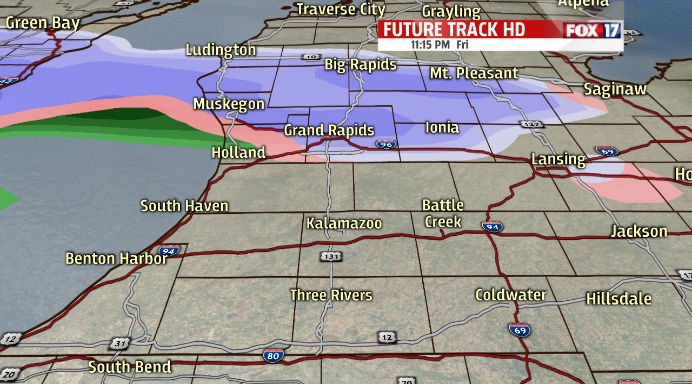
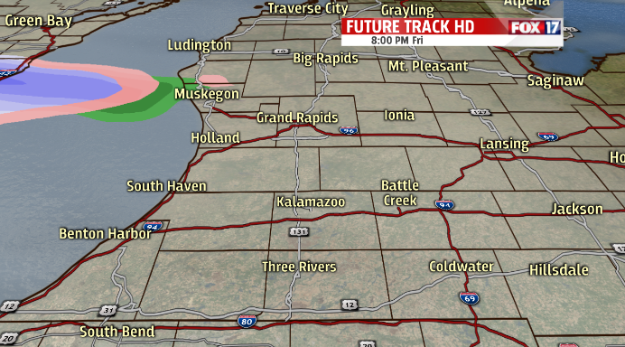
Just before midnight, precipitation spreads onshore. This particular look at Future Track doesn’t show any precipitation to the south of Interstate 96. This doesn’t mean there won’t be any precipitation at this time, but does along with the position of the storm. As it gets closer, you’ll see it fill in throughout the morning.

This is where the forecast becomes a bit more challenging. You see three different colors on the map. The blue/purple hue is all snow, pink is a mix of rain and snow, and green is all rain. I believe at this time, as temps stay at or above freezing, most of the snow will melt. The ground is still very warm, and we’re seeing the warm water temperatures affect the immediate lakeshore.
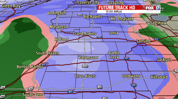
By late morning Saturday, a transition to more snow will occur. Still, we’ll see the mix of rain and snow to the south, limiting our accumulation totals. By the afternoon, however, colder air continues to move in and that’s when we will see our best chance for accumulating snow areawide.

Now for the question everyone wants answered: how much?! There are several variables that will go into determining how much snow we’ll receive. This is obviously our first snowfall of the season, so it will take a little longer to conquer the warm soil temperatures. Most surface soil temps are still in the upper 40s. Temperatures will not be at their coldest with this storm until later Saturday, so the first snow that falls will most likely melt on contact for a little while. As uncertain as several things are, one of the more certain things in the forecast is that we’ll enjoy our first accumulating snow in West Michigan.
This forecast is likely to change over the next 24 hours, and we'll continue to update you on this approaching storm. For the latest information, visit FOX 17 Weather for more.
