
WEST MICHIGAN — (FOX 17) — Most areas had sunny skies for most of the day Tuesday, but it appears more snow is on the way Wednesday.
The above image from our in-house computer model, Future Track, shows some of the totals. As you can see, we’re not expecting a lot of snow. Most areas will end up with one to three inches.
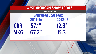
Of course, it has been a very snowy winter, especially compared to last year. Here is a look at the totals so far this year in Grand Rapids and Muskegon, as well as the amount at this point last season. As you can see, there’s “snow” comparison between the two winters:
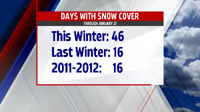
Finally, if it seems like we haven’t seen much grass lately, that’s because we haven’t. Check this graphic out. It shows the number of days so far with at least an inch of snow on the ground. So far this year, there have been 46 such days, more than the past two years combined. Days with snow cover is a good gauge of how cold a winter is. Obviously, colder temperatures aren’t conducive to melting snow. Therefore, a higher number of days with snow on the ground translates to a colder winter.
For the latest on the snow and cold, join us on FOX 17 News or visit the weather page anytime at http://www.fox17online.com/weather
