


WEST MICHIGAN — From Fox 17 Weather Ready Meteorologist Kara James: We have finally started to thaw out in West Michigan, after almost 3 weeks of below average temperatures (and mostly below freezing!) Highs will reach the mid-30s with pockets of sun Wednesday, and 40s Thursday! We stay dry through Wednesday, but still breezy with feels like temperatures around 10 degrees colder than actual temperatures. The next storm system arrives Thursday, starting as rain during the day and helping to melt much of the snowpack. Then as the cold front part of the system sweeps through, rain will change to snow in the evening and overnight. A "flash freeze" is likely Thursday night into early Friday, as temperatures crash back below freezing. Scattered snow showers continue Friday as the sharply colder returns, with highs back in the 20s. This time around, the much colder air mass will be temporary. The weekend should be quiet, with highs back in the 30s. Looking ahead, temperatures will likely remain "near average" next weekend into Christmas week.
TONIGHT: Mostly cloudy. Breezy. Chance few sprinkles. Steady temps in the low 30s. Winds: W 10-20 mph
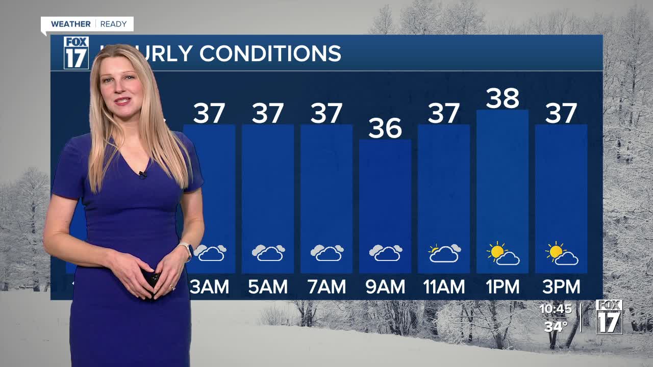
WEDNESDAY: Mostly cloudy early, but becoming partly cloudy in the afternoon. Highs in the mid 30s. Winds: S 10 - 20 mph
THURSDAY: Widespread rain showers for most of the day. Highs in the low 40s.
THURSDAY NIGHT: Falling temperatures will lead to flash-freezing, with rain changing to snow showers. Lows around 20.
FRIDAY: Colder again with a few snow showers. Highs in the upper 20s.
SATURDAY: Mostly cloudy. Chance for a few flurries. Highs in the mid- 30s.
SUNDAY: WINTER SOLSTICE 10:03AM Mostly cloudy. Highs in the mid-30s.
MONDAY: Mostly cloudy. Highs in the low 30s.
TUESDAY: Mostly cloudy. Quiet. Highs in the low-mid 30s.
For the latest details on the weather in West Michigan, head to the FOX 17 Weather page.
Follow FOX 17: Facebook - X (formerly Twitter) - Instagram - YouTube
