
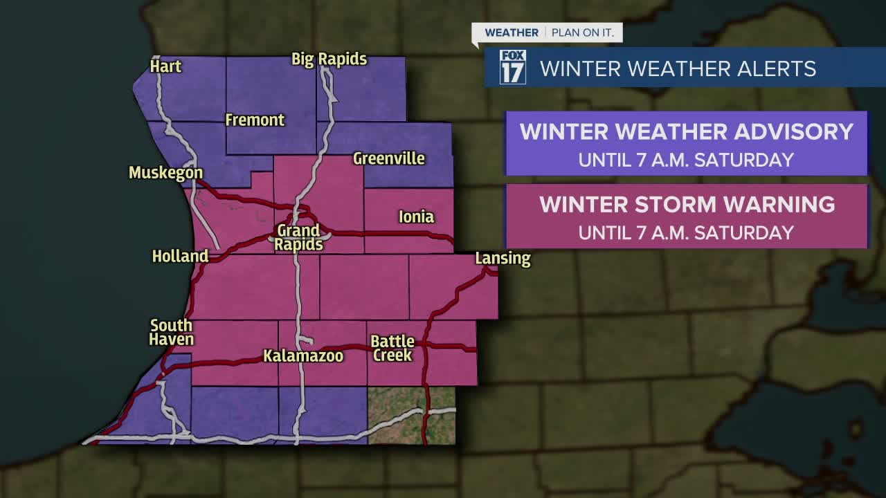


WEST MICHIGAN — The forecast from FOX 17 Meteorologist Haleigh Vaughn: Steady winds and colder temperatures fire up the lake effect snow machine this week and weekend! Crashing temperatures are in store on Friday and through the weekend, with daytime highs in the 20s and overnight lows in the teens. That will likely prompt heavier lake effect snow! Our forecast models are indicating winds during this time frame will be predominately westerly, which will drive the snow to the U.S. 131 corridor and even further east. A WINTER STORM WARNING is in effect until 7 a.m. Saturday for Ottawa, Allegan, Van Buren, Kent, Ionia, Barry, Eaton, Kalamazoo, and Calhoun counties. An additional 5" to 7" of snow accumulation will be possible by Saturday morning for those counties. Isolated higher amounts are possible, especially along the U.S. 131 corridor between Grand Rapids and Kalamazoo. A WINTER WEATHER ADVISORY is in effect until 7 a.m. Saturday for Oceana and Muskegon counties, where an additional 3" to 5" will be possible. A WINTER WEATHER ADVISORY is in effect for Newaygo, Mecosta, and Montcalm counties through 7 a.m. Saturday, where an additional 2" to 4" will be possible. A WINTER WEATHER ADVISORY is in effect for Berrien, Cass, and St. Joseph counties until 7 p.m. Friday, where 3" to 6" of snow is possible. We slowly turn off this lake effect snow machine on Sunday as dry conditions return! Warmer temperatures are in the forecast next week, in addition to slightly warmer temperatures. Many spots could jump back to the lower 40s before Thanksgiving! Download the free FOX 17 Weather App for the latest forecast video.
OVERNIGHT: Cloudy and breezy with lake effect snow. Lows in the middle 20s. Winds west-northwest at 10 to 15 mph.
FRIDAY: Cloudy, breezy, and colder. Lake effect snow likely. Highs in the upper 20s to near 30 degrees. Winds west at 10 to 15 mph.
SATURDAY: Cloudy, breezy, and cold. Lake effect snow likely. The heaviest will be along/west of U.S. 131. Highs in the middle 20s.
SUNDAY: Cloudy, breezy, and the coldest day of the week/weekend. Lake effect snow will gradually diminish through the day as drier air filters in. Highs in the middle 20s.
MONDAY: Mostly to partly cloudy and a bit warmer. Highs in the lower 30s.
TUESDAY: Partly cloudy. Highs in the upper 30s.
For the latest details on the weather in West Michigan, head to the FOX 17 Weather page.
