
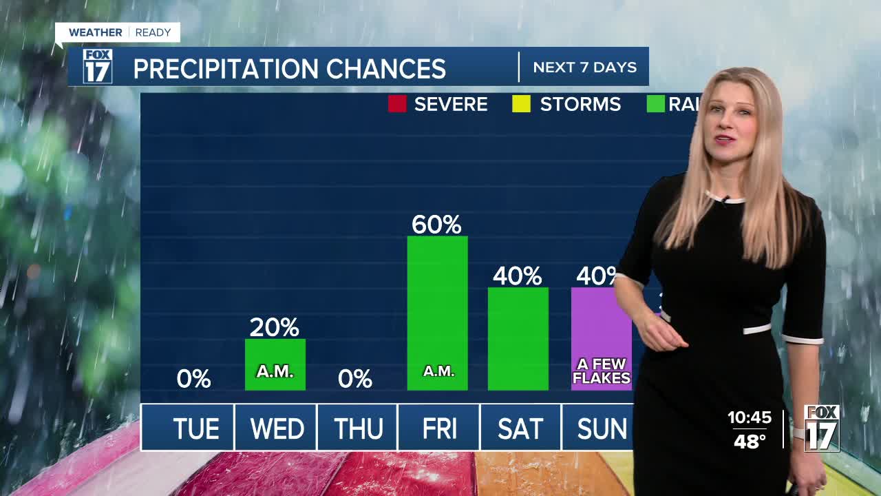


WEST MICHIGAN — The forecast from FOX 17 Weather Ready Meteorologist Kara James: While it won't be as breezy overnight, gusts could top 15-20 mph at the lakeshore into early Tuesday morning. Tuesday will be a pleasant, mostly sunny day before an active stretch sets up. A few showers are possible again Wednesday and Friday with clipper systems moving through the Great Lakes region. Temperatures remain above average through this week, with high temperatures in the mid/upper 50s and mornings in the mid/upper 30s. A sharply colder air mass is expected by Sunday, with the potential for a few slushy snowflakes to mix in with rain late this weekend and early next week! The "average" first snow in Grand Rapids is November 8, so this would be right on schedule. Even though there's no significant snow in the forecast anytime soon, the Odd-Even Parking Rules are now in effect in Grand Rapids. Stay with the FOX 17 Weather Ready Team for your latest forecast updates.
TONIGHT: Winds relax. Clear to partly cloudy. Lows in the upper 30s. Winds: W 5-15 mph
TUESDAY: Mostly sunny to partly cloudy. Pleasant. Highs in the mid 50s. Winds: SW 5-15 mph
WEDNESDAY: Partly sunny with isolated showers. Another windy day. Highs in the mid 50s.
THURSDAY: Partly cloudy. Highs in the low to mid 50s.
FRIDAY: Mostly cloudy with showers likely. Highs in the mid 50s.
SATURDAY: Partly cloudy and cool. Chance isolated showers in the later part of the day. Highs in the upper 40s.
SUNDAY: Chance few showers, mixed with slushy snowflakes. Turning Colder. Highs: mid-40s.
MONDAY: Breezy and much colder. Scattered showers with slushy snowflakes mixing in. Highs in the mid 30s.
For the latest details on the weather in West Michigan, head to the FOX 17 Weather page.
Follow FOX 17: Facebook - X (formerly Twitter) - Instagram - YouTube
