
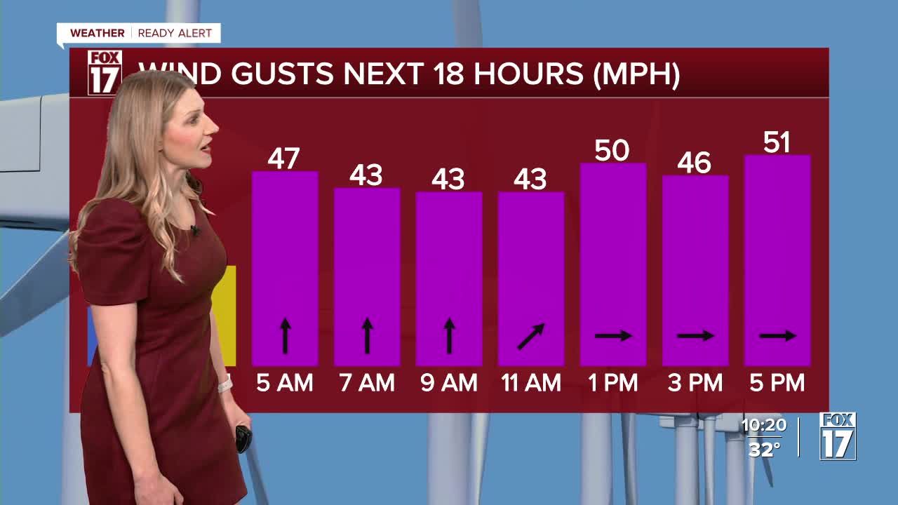


The forecast from FOX 17 Weather Ready Meteorologist Kara James: A strong Alberta Clipper system (from Canada) arrives late tonight into Friday. This will spread rain and snow across West Michigan during the early part of Friday. There may be some minor, grassy accumulations in spots in/around Grand Rapids, but a quick burst of 2" to 3" is possible across our northern counties. This system will generate very windy conditions with inland gusts of 45 to 50 mph, and gusts at the lakeshore of 55 to 60 mph. A FOX 17 WEATHER READY ALERT has been issued along with a HIGH WIND WARNING as we expect scattered power outages, difficulty driving on north/south roads, and blowing snow. Most of Saturday looks dry, but Saturday night into Sunday another system arrives. This systems bears watching as we are currently seeing rain, snow, wintry icy mix, and perhaps a thunderstorm in spots. Some models bring mostly rain and a little snow to West Michigan, while others bring more wintry weather. Any accumulation in our area would likely occur from Grand Rapids to the north. This will be a system to keep an eye on in the days to come as travel impacts could be possible Sunday. The system looks to produce very heavy snow across northern lower Michigan and north central lower Michigan. Forecast details and amounts have yet to be worked out, but suffice to say a winter storm in these areas is possible. Beyond that system we cool down even further with some lake effect snow showers possible early next week.
TONIGHT: Becoming cloudy with rain and snow developing. A quick burst of snow may lay down an inch or so around Grand Rapids, with 2" to 3" possible across our northern counties. Lows in the lower 30s. Winds will increase from the southeast at 15 to 25 mph.
FRIDAY: WEATHER READY ALERT / HIGH WIND WARNING Rain and snow showers likely. Another 1" to 2" possible north of Grand Rapids. Very windy. Highs around 40. Winds southwest/west at 20 to 30 mph. Gusting 55 to 60 mph.
SATURDAY: Partly sunny early, becoming mostly cloudy. A wintry mix of rain, snow, and ice develops overnight. Highs in the upper 30s.
SUNDAY: Cloudy and windy with a wintry mix of rain, snow, and ice. A thunderstorm possible south of Grand Rapids, while some accumulation of snow is possible north of Grand Rapids. Highs in the mid 40s, but warmer across our southern counties (low/mid 50s).
MONDAY: Cloudy, windy, and sharply colder with snow showers. Accumulations possible. Highs in the mid/upper 20s.
TUESDAY: Mostly cloudy with a few lake effect snow showers or flurries. Highs in the mid 20s.
WEDNESDAY: Mostly cloudy with chance snow showers. Highs in the lower 30s.
THURSDAY: Partly cloudy and warmer with highs in the upper 40s.
For the latest details on the weather in West Michigan, head to the FOX 17 Weather page.
Follow FOX 17: Facebook - X (formerly Twitter) - Instagram - YouTube
