
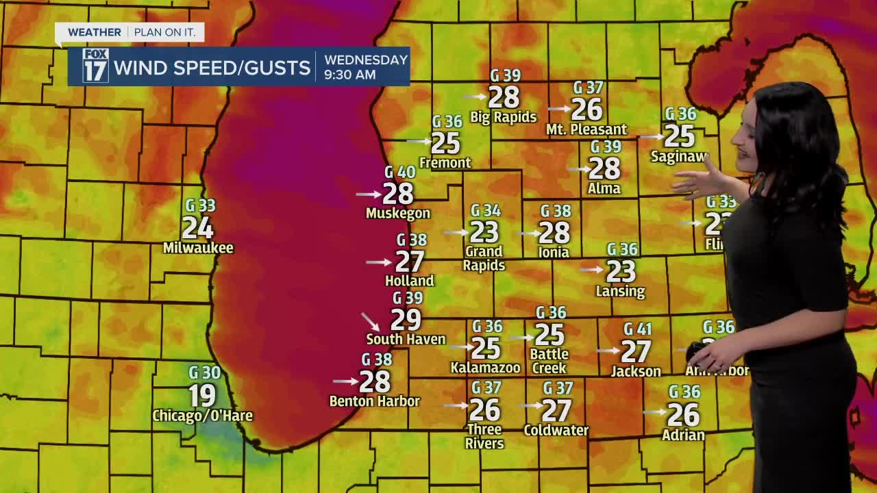


WEST MICHIGAN — The forecast from FOX 17 Meteorologist Haleigh Vaughn: Scattered rain showers continue overnight until a strong cold front shifts in from the west, transitioning rain over to lake enhanced snow showers. Any snow accumulation will be minor! Temperatures quickly tumble through the early morning hours on Wednesday, becoming sharply cooler with temperatures only in the 30s for the majority of the day. Winds will be exceptionally strong overnight and into Wednesday, with wind gusts potentially up to 45 mph. A WIND ADVISORY is in effect for all of West Michigan until 8 p.m. Wednesday. Isolated power outages will be possible, with winds shifting from the south to the west once the front passes. Factoring in the already cold temperatures and strong wind gusts, the feels-like temperatures will remain in the teens all day long! Don't forget your extra warm layers. Roadways are likely to be slick in spots, along with bridges and overpasses. Cloudy skies are in store for Thursday and Friday, with temperatures rebounding to the 40s by Friday. Another system with a transition from rain to snow and strong wind gusts is on tap for Saturday! Quickly falling temperatures are likely between Saturday and Sunday. Download the free FOX 17 Weather App for the latest forecast video.
TONIGHT: Cloudy and windy with scattered rain showers, perhaps a rumble of thunder. Quickly falling temperatures. Shifting winds from the south to the west at 15 to 30 mph, with gusts up to 45 mph.
WEDNESDAY: Cloudy and windy with rain showers transitioning to light snow showers as temperatures crash into the low/mid 30s. Little to no snow accumulation. Our warmest temperatures will occur around/after midnight in the lower 50s, then fall into the 30s the remainder of the day. Westerly winds at 15 to 30 mph with gusts up to 45 mph. Wind chills in the teens all day!
THURSDAY: Morning clouds and a few snowflakes, with sunshine returning in the afternoon! Highs in the lower 30s.
FRIDAY: Partly cloudy. Highs in the middle 40s.
SATURDAY: Cloudy and windy with rain showers transitioning to like snow showers. Quickly dropping temperatures and windy!
SUNDAY: A few flurries possible in the morning. Partly sunny to mostly cloudy. Highs in the upper 30s.
For the latest details on the weather in West Michigan, head to the FOX 17 Weather page.
