
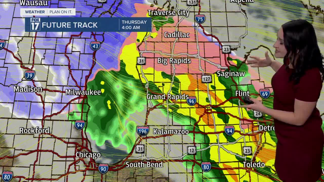


WEST MICHIGAN — The forecast from FOX 17 Meteorologist Haleigh Vaughn: A widespread wave of rain, freezing rain, snow, and strong winds develops over West Michigan tonight and into early Thursday morning. Travel impacts are likely for the Thursday morning commute, primarily along and north of I-96. This includes the region extending from Muskegon through Lansing, and north of Grand Rapids. A WINTER WEATHER ADVISORY is in effect for Oceana, Newaygo, Mecosta, and Montcalm counties until 9 a.m. Thursday where total snow accumulations up to 1" and ice accumulation around two tenths of an inch are possible. While this may not seem like a ton of ice accumulation, even a light glaze can produce slick travel. There is also a WIND ADVISORY in effect for almost all of West Michigan with wind gusts potentially up to 50 mph. Dry air filters in for Thursday afternoon (in what we call the dry slot of a larger system) before snow ramps up Thursday night into Friday. Temperatures tumble and snowfall picks up for Friday with strong winds from the southwest. Lake effect snow develops through the day on Saturday, eventually dwindling through the day on Sunday. A few flurries are possible on Monday, with dry skies next Tuesday. Looking for information on whether we could see a White Christmas? The latest long-range forecast suggests colder temperatures and the chance of snow before Christmas day. In fact, there's an 80 to 90 percent chance of below normal temperatures Christmas week. Click here for more on whether we could see a White Christmas! Stay tuned with the FOX 17 Weather Team for updates as Christmas gets closer. Download the free FOX 17 Weather App for the latest forecast video.
TONIGHT: Cloudy with a wintry mix. Lows in the lower 30s. Winds east-southeast at 15 to 25 mph. Gusts to 45 mph.
THURSDAY: A wintry mix likely early Thursday morning (especially along and north of I-96), otherwise cloudy skies. Snow ramps up late Thursday night. Breezy all day! Highs in the lower 40s. Winds south/southwest at 10 to 20 mph. Individual gusts could reach 30 to 40 mph.
FRIDAY: Lake effect snow showers develop. Breezy conditions with winds southwest/west at 10 to 20 mph. Wind gusts up to 30 mph possible. Accumulations likely. Highs in the middle 30s.
SATURDAY: Cloudy with lake effect snow showers. Accumulations likely. Highs in the upper 20s.
SUNDAY: Mostly cloudy with lake effect snow showers diminishing by mid-day. Highs in the upper 20s.
MONDAY: Mostly cloudy with the chance of flurries. Highs in the upper 20s.
TUESDAY: Mostly cloudy. Highs in the mid to upper 20s.
For the latest details on the weather in West Michigan, head to the FOX 17 Weather page.
