
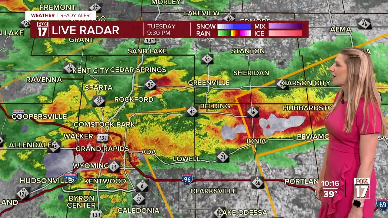


The forecast from FOX 17 Weather Ready Meteorologist Kara James: There is a FOX 17 WEATHER READY ALERT through Wednesday morning for the possibility of strong to severe storms through 3 a.m. A SEVERE THUNDERSTORM WATCH has been issued for Muskegon, Ottawa, Allegan, Van Buren, Kent, Barry and Kalamazoo counties until 1 a.m. for wind gusts up to 75 mph and hail up to golf ball size, and a TORNADO WATCH through 2 a.m. for Berrien, Cass, St Joseph and Branch counties. A warm front will try to lift through West Michigan. Areas south of the front will be very warm but cooler north, with higher chances of storms in the warmer areas. Right now, that front looks like it will make it to the I-94 corridor with a higher tornado threat there compared to the rest of West Michigan. Heavy rain could also lead to street flooding. A Flood Watch has been issued for Van Buren, Kalamazoo, Calhoun and counties south through 11 a.m. Wednesday for the possibility of flooding due to 1-2" of rain. Storms and rain end Wednesday morning, and colder air drawn in Wednesday afternoon may change rain to snow. No accumulation is expected. The remainder of the week will be much colder and active. Another system will bring some rain/snow Thursday night into Friday. Extremely strong winds are also likely Friday.
TONIGHT: Rain and thunderstorms. Some storms may be strong to severe, with torrential rain leading to flooding. Damaging winds, hail, and a few tornadoes are possible, especially south. Lows around 40. Winds east at 5 to 15 mph.
WEDNESDAY: Cloudy and breezy with rain likely, especially in the morning. Rain could mix with snow showers later in the day. Highs in the mid 40s early, then falling through the day. Winds northwest at 10 to 20 mph.
THURSDAY: Mostly sunny to partly cloudy and cool. Highs around 40.
FRIDAY: Rain and snow showers likely. Very windy. Highs in the lower 40s.
SATURDAY: Partly sunny. Becoming mostly cloudy in the evening with the chance of rain/snow showers late. Highs around 40.
SUNDAY: Rain and snow showers likely. Highs in the lower 40s.
MONDAY: Mostly cloudy with snow showers. Highs in the upper 20s.
TUESDAY: Mostly cloudy with a few flurries. Highs in the upper 20s.
For the latest details on the weather in West Michigan, head to the FOX 17 Weather page.
Follow FOX 17: Facebook - X (formerly Twitter) - Instagram - YouTube
