


WEST MICHIGAN — Severe Weather Awareness Weeks are scheduled across the county as an opportunity to raise awareness of severe weather hazards. It's a time to prepare and learn how to stay safe in severe storms. They are often scheduled ahead of the typical severe weather season for each state. In Michigan, Severe Weather Awareness Week is March 17 through March 23.
The best way to stay safe during severe weather in West Michigan is to be both prepared and informed. The FOX 17 Weather Team will be explaining severe weather conditions and severe weather safety tips all week long. Click here for our daily coverage on Severe Weather Awareness Week.
Today's Question: What are the various severe thunderstorm risk categories and what do they mean?
When severe thunderstorms are possible, the NOAA Storm Prediction Center releases severe weather outlooks based on the potential risk. You might see the FOX 17 Weather Team share these outlooks ahead of potential severe weather events. Below is a breakdown of the various severe thunderstorm risk categories.
The pale green indicates that thunderstorms are possible, but they will not likely meet the severe criteria. Are you curious about what makes a thunderstorm severe? Click here for our previous Severe Weather Awareness Week coverage.
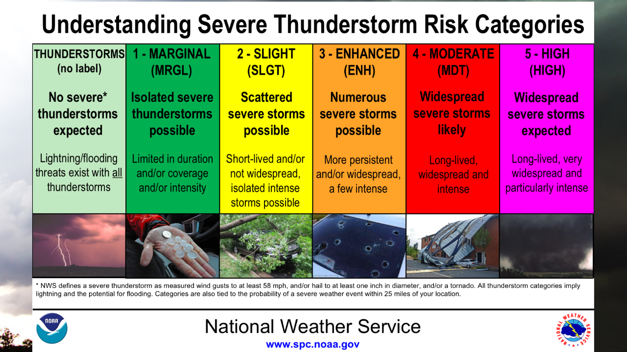
The severe thunderstorm risk categories are labeled one through five.
Level one, or the dark green, represents a MARGINAL RISK for severe thunderstorms. This means that if a severe thunderstorm develops, it will likely be isolated. The storm is likely to be limited in duration, coverage, and intensity. There's often a low risk for a tornado.
Level two, or the color yellow, represents a SLIGHT RISK for severe thunderstorms. A level two risk indicates the possibility of scattered severe thunderstorms. While they could still be short-lived, there is a greater likelihood of intensity.

A level three, or the color orange, represents an ENHANCED RISK for severe thunderstorms. A level three risk indicates the possibility of numerous severe thunderstorms. They are likely to be persistent and a few could be intense. A few tornadoes are possible, and there could be several reports of wind damage.
A level four, or the color red, represents a MODERATE RISK for severe thunderstorms. A level four risk indicates the possibility of widespread, long-lived, and intense severe thunderstorms. Strong tornadoes and large hail are possible, along with widespread wind damage.
The highest level, a level five, represents a HIGH RISK for severe thunderstorms. This is represented by the color pink, and it indicates the possibility of widespread, long-lived, and very intense severe thunderstorms. Under a HIGH RISK, a tornado outbreak is possible, along with significant and widespread damage.

In the case of a Tornado Warning, it's important to know where to go. Click here for our previous Severe Weather Awareness Week Coverage.
To remain informed about severe weather outlooks, stay tuned with the FOX 17 Weather Team. You can follow us on social media, download the FOX 17 News app, and watch FOX 17 News.
For the latest details on the weather in West Michigan, head to the FOX 17 Weather page.
Follow FOX 17: Facebook - X (formerly Twitter) - Instagram - YouTube
