


GRAND RAPIDS, Mich. — FEMA hasn't updated its maps in four decades. But that's changing. For West Michigan, it means your city might be in an updated flood zone on the new federal flood maps.
Among the places looking to adopt the measures is the City of Grand Rapids.
"FEMA is in the process of what's called a map modernization process," Grand Rapids City Engineer Tim Burkman told FOX 17
Since the maps were made, back in 1982, a lot has changed, namely, technology.
"The old maps are paper maps, PDF scans, and so getting an exact percent change, especially when you consider the line width on those maps is difficult," Burkman said.

Now digitalized, FEMA has new maps with current flood zones.
"So those maps identify areas that are subject to flooding in what we call the 100-year flood event or the one in 100 chance or 1% chance event of occurring in any given year," Burkman said.
The flood maps are now online, but in a pending section. To find out if you're in the flood zone you have to click here. Once at the website put your address in the designated area. What you see is the map that dates back to 1982.
You're not done yet!
Next, you have to click on Show ALL Products, but keep in mind it's going to take a minute to load up. Then select Pending Product and in the drop-down menu find FIRM (Flood Insurance Rate Map) Panels. If you want to download all of the information, hit DL ALL, but if you just want to view it, hit FIRM Panels and the list will to pop up. Then, find the quadrant you live in with the overall map. Take that quadrant number and match it to the number within that same list.

Burkman says you could also wait until February 23rd when the maps go live on the FEMA website in the address section.
"If we were not to incorporate the FEMA flood insurance study, as well as the flood insurance rate maps, we would not be eligible to participate in the National Flood Insurance Program," he added.
If the city agrees with these new measures it'll be cheaper rates for those in flood zones, Burkman said.
"This covers not just the Grand River, but all streams throughout the city, and being able to identify those areas. So that property owners are informed is important," he told FOX 17
Once you access the maps, you can see a picture of the different flood events. The blue- and red-striped area shows the regulatory floodway like Riverside Park.
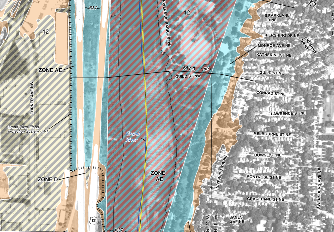
Blue represents a 100-year or 1% chance for a flood of that size in any given year. Brown represents a 500-year flood or .2% chance of a major flood happening.
"When you speak of the Grand River and the flood protection system that the city's invested in, we've made over $5 million of improvements, since that 2013 flood event, and that was tested in 2018, with what we saw, and it performed very well," Burkman said.
The 2013 flood saw major rises in water levels downtown, but it wasn’t even a 100-year flood event.

"So the city has through FEMA, what's called a freeboard deficient certification of our flood protection system, which means we're protected up to and above in some cases, the 100-year flood stage event.
While things are being updated as the city changes, officials say there’s one important note to keep in mind.
"We have seen line shifts of up to 50 feet in some cases, but generally, the changes in the area are insignificant," Burkman said.
