
GRAND RAPIDS, Mich. (March 11, 2014) — After a brief break from the snow and cold, it’s back to winter for West Michigan later tonight and Wednesday as well.
The above map shows a wide range of snowfall amounts from our in-house computer model, Future Track. Areas along and north of I-96 will have virtually no snow, while areas along and south of I-94 could end up with over a half foot. Because of Tuesday’s rain and melting snow, there could be some icy spots anywhere in West Michigan in the morning.
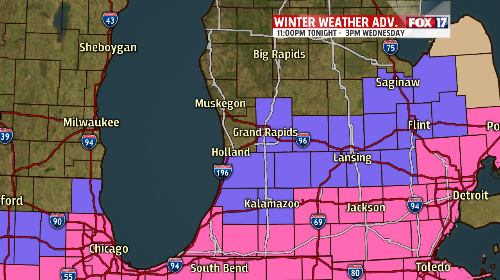
The map below shows the advisories and warnings that are in effect. The counties in purple, which includes Kent, Ionia, Allegan, Barry, Eaton, Van Buren, and Kalamazoo, are all under a winter weather advisory from 11:00pm Tuesday night until 3:00 Wednesday afternoon. The counties in pink, Calhoun, Berrien, Cass, St. Joseph, and Branch are under a winter storm warning for the same timeframe.
We’ll have updates on this developing winter storm on FOX 17 News at 10. Radar is available anytime athttp://www.fox17online.com/weather