


The summer months have been incredibly dry for most of West Michigan, with some spots like Holland recording the driest summer (so far) on record. It doesn't look like much improvement will be on the way from Mother Nature through the end of August, which is also the end of "meteorological summer". It's not much of a coincidence that it has also been a very hot summer, with almost all reporting locations in West Michigan exceeding the average number of 90 degree days.
Check out how far below average most of West Michigan is in terms of rain, as of Sunday, August 10:
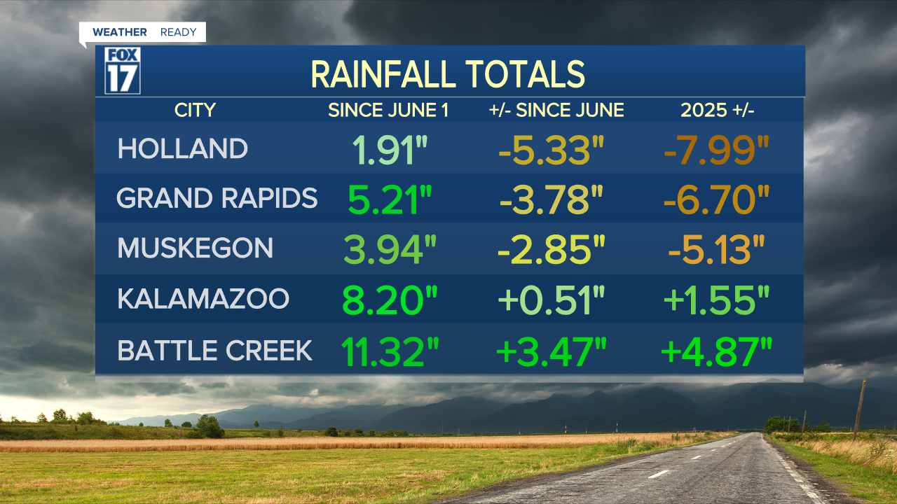
Kalamazoo and Battle Creek both had above average rainfall from scattered showers and storms in July. Even though it's been dry in August, the surplus in those locations continues due to how much rain was received in July! It's the tale of the haves and have-nots in terms of rainfall across West Michigan.
The most recent drought monitor shows the lakeshore through 131 in level 2 "Moderate" drought, with parts of Ottawa and Allegan county around Holland in level 3 "Severe" drought. This makes sense given how dry these areas in particular have been over the last 2.5 months. The soils are drying out, vegetation is brown and crunchy, and there could be some longer term effects due to the duration of this drought.

Now, for what's ahead...not much, in terms of rain. The medium-range outlooks for 6-10 days from now and 8-14 days from now don't show a lot of hope for West Michigan.

While the Great Lakes region has some chances of rain this week with a cold front, the light green contour indicates low confidence of above average rainfall. Most of West Michigan is not even included in that contour, meaning there is an equal chance of above average or below average rainfall. This doesn't necessarily mean we won't get a single drop of rain (most of us will get some measurable rain this week); but overall during the time period of August 16 through 20, the chances of meaningful widespread rainfall are slim.
It gets even worse for the 8-14 day outlook valid August 18 through 24. West Michigan and much of the Great Lakes are in the moderate confidence area for drier than average conditions.

The temperature outlook for 6-10 days and 8-14 days goes hand in hand with the precipitation outlook.
There is high confidence of above average temperatures for most of the eastern 2/3 of the nation, including West Michigan. The darker the red colors are, the higher the confidence level in the forecast. We are in the darkest red color, and the forecast toward the end of the week and weekend again favors upper 80s and low 90s across the board.

Looking forward into the future for in the 8-14 day outlook, warmer than average temperatures look to continue to prevail across the Lower 48. Average highs for West Michigan during this timeframe is low 80s.

The bottom line for us is...staying mainly dry through a lot of the remainder of August, with more warmer than average days than not. Isolated areas of downpours and a few cooler than average days are possible here and there, but there are no signals of decent cooldowns or significant widespread rainfall.
For the latest details on the weather in West Michigan, head to the FOX 17 Weather page.
Follow FOX 17: Facebook - X (formerly Twitter) - Instagram - YouTube
