
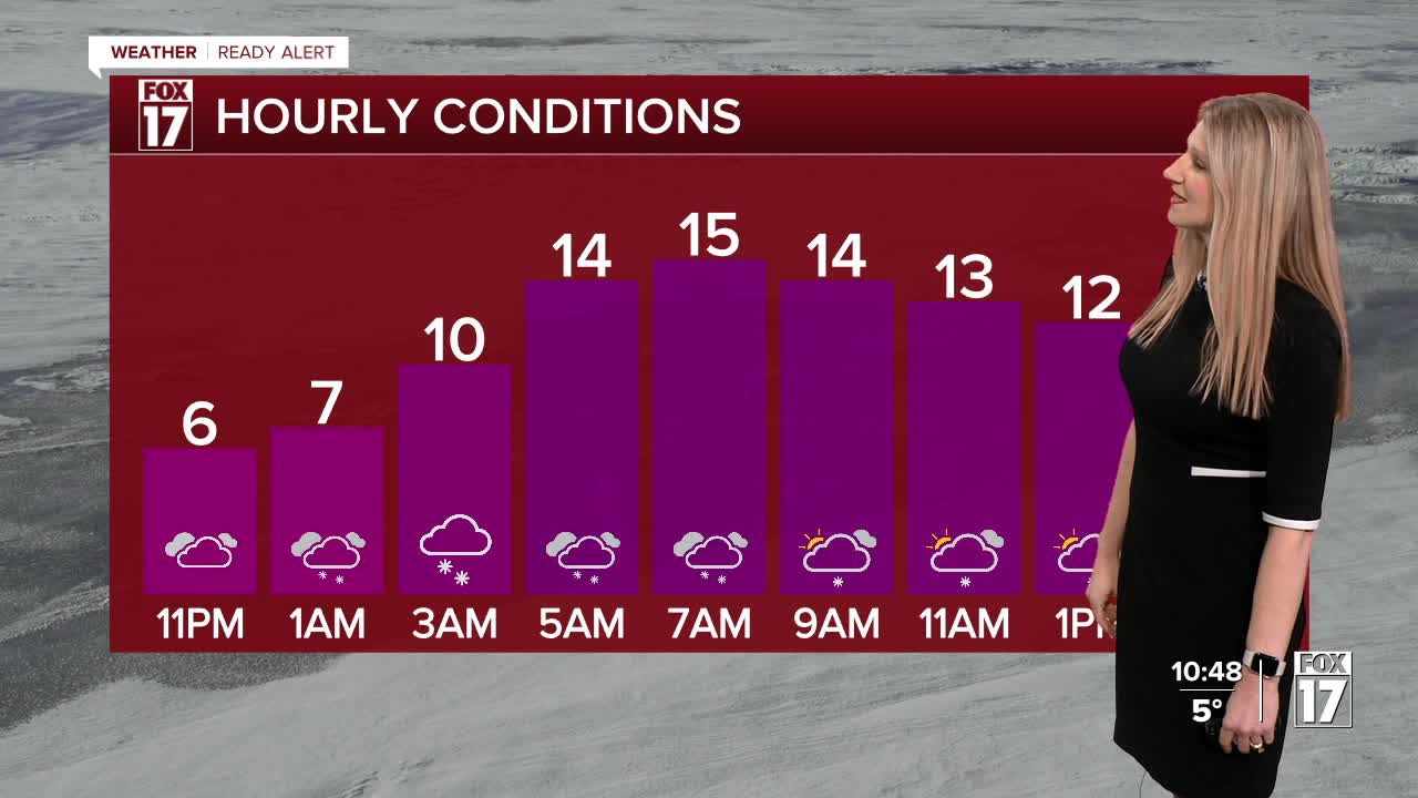


WEST MICHIGAN — From Fox 17 Weather Ready Meteorologist Kara James: Cold, snowy and breezy days continue this week in West Michigan. Snow showers return overnight with the next clipper system, and a WINTER WEATHER ADVISORY has been issued for the lakeshore, Newaygo, Kent, Barry, Kalamazoo, Cass and St. Joseph counties from midnight to 7 p.m. Tuesday. Snow totals will be 2-4" with isolated higher amounts. Gusty winds will lead to blowing snow and reduced visibility, continuing the poor driving conditions. With strong winds and cold temperatures overnight a COLD WEATHER ADVISORY is in effect through 10 a.m. Wind chills will be well below zero; as cold as -15 to -20 in some locations. The overall pattern remains much colder than average all week; with lows remaining in the single digits, highs mainly in the teens, and occasional snow showers each day. The pattern shifts a little bit starting this weekend, with lower snow chances, highs in the 20s and a peek of sun or two possible.
There are several flight delays and cancellations due to the weekend storm system. Here's the direct link to the Flight Tracker at the Gerald R. Ford International Airport
TONIGHT: COLD WEATHER ADVISORY (SE of Grand Rapids) Snow showers, and windy. Lows: 5-10. Wind chills as low as -15 to -25.
TUESDAY: Windy and very cold with snow likely. Morning wind chills -10 to -25. Highs in the teens, falling to around 12 in the afternoon.
WEDNESDAY: Scattered snow showers. Highs in the mid-teens.
THURSDAY: Scattered lake effect snow showers. Highs in the mid-teens.
FRIDAY: Mostly cloudy and very cold. Highs around 10.
SATURDAY: Partly cloudy and cold. Highs in the teens.
SUNDAY: Partly cloudy. Highs in the low 20s.
MONDAY: Mostly cloudy with chance snow showers. Highs in the mid 20s.
For the latest details on the weather in West Michigan, head to the FOX 17 Weather page.
Follow FOX 17: Facebook - X (formerly Twitter) - Instagram - YouTube
