


The forecast from FOX 17 Weather Ready Meteorologist Kara James: A warm front lifts in to West Michigan overnight, bringing increasing clouds and a few very light showers before dawn. Friday will be a cloudy and warmer day with highs in the upper 60s, as humidity increases. "Average" highs are now in the lower 60s, so this is still above average. Widespread on and off rain is in the forecast for Saturday, Saturday night, and into Sunday with a strong low pressure system. A few thunderstorms are possible on Saturday as well. Totals will be around an inch for most, with isolated higher amounts. This much-needed rain will help chip away at the moderate to severe drought that has built into most of the Lower Peninsula. Sunday will be a cool and blustery day. The active weather continues next week, with additional rain and cool air. Stay with the FOX 17 Weather Ready Team for your latest forecast updates.
TONIGHT: Mostly cloudy with a chance of light rain showers. Lows in the upper 40s. Winds south/southeast 5 to 10 mph.
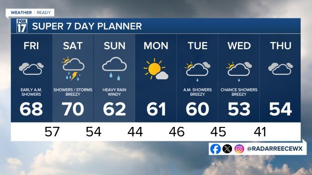
FRIDAY: Partly sunny to mostly cloudy. Chance of showers early as a warm front lifts through the state. Highs in the upper 60s.
SATURDAY: Cloudy with rain showers likely. Some thunderstorms possible. Highs around 70.
SUNDAY: Cloudy and cooler with a chance of morning rain showers. Windy. Highs in the low 60s.
MONDAY: Mostly sunny to partly cloudy. Highs in the upper 50s.
TUESDAY: Mostly cloudy with rain showers early. Highs around 60.
WEDNESDAY: Mostly cloudy with a chance of showers. Highs in the low 50s.
THURSDAY: Cloudy and cool. Highs in the low 50s.
For the latest details on the weather in West Michigan, head to the FOX 17 Weather page.
Follow FOX 17: Facebook - X (formerly Twitter) - Instagram - YouTube
