


The forecast from FOX 17 Meteorologist Kara James: Snow showers will be winding down tonight along the lakeshore, but isolated lake effect is possible south of South Haven. The rest of West Michigan will be partly cloudy and very cold overnight, with lows in the mid-teens. The wind will relax tonight, but wind chills will still be a few degrees colder than actual temperatures. A clipper system tracking mainly north into Canada will bring another round of light snow tomorrow afternoon into Wednesday morning, mainly from Grand Rapids northward. We expect about 1" to 2" in these areas, with isolated higher amounts around 3" possible across Oceana, northern Newaygo, and Mecosta Counties and around half an inch from I-96 south. The rest of the work week will be mainly dry, with the warmest day Friday in the mid-40s. Saturday night into Sunday the next system arrives, with the chance for snow showers and continued colder air. Longer range temperature outlooks still keep Michigan in at/above normal readings into the first full week of March. Normal highs are in the mid 30s, so no Arctic air is on the horizon or big storms at this time.
TONIGHT: Partly cloudy and cold. Lows around 15. Winds north to south 5 to 10 mph.
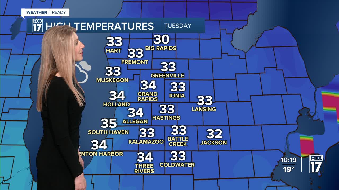
TOMORROW: Mostly cloudy, breezy, and warmer with late day snow showers. Total accumulation by Wednesday morning about 1" to 2", with 0.5" south of I-96. Highs in the mid 30s. Winds south at 10 to 20 mph.
WEDNESDAY: Morning clouds/flurries, otherwise partly sunny by the afternoon. Highs in the low 30s.
THURSDAY: Partly sunny to mostly cloudy. Highs in the lower 30s.
FRIDAY: Mostly sunny to partly cloudy and mild. Highs in the mid 40s.
SATURDAY: Partly cloudy to partly sunny. Slight chance of late day snow showers. Highs around 40.
SUNDAY: Mostly cloudy with a chance of rain/snow showers. Highs around 30.
MONDAY: Mostly cloudy with a chance of snow showers. Highs in the upper 20s.
For the latest details on the weather in West Michigan, head to the FOX 17 Weather page.
Follow FOX 17: Facebook - X (formerly Twitter) - Instagram - YouTube
