
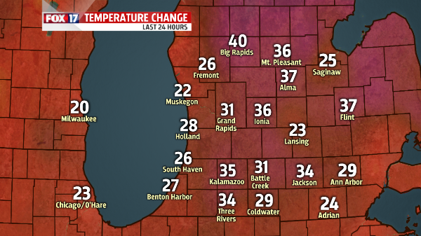
 WEST MICHIGAN — What a difference a day makes, yesterday the entire State of Michigan was below zero and this morning temperatures were between 20 and 40 degrees warmer. Temperatures warmed overnight allowing for early morning temperatures in the low 20’s making it feel much warmer than the record-setting low temperatures just a day earlier. Light snow also fell around West Michigan in the morning hours. The heaviest snow stayed mostly north of I-196 allowing for one to three inches to accumulate. Areas to the south like Kalamazoo and Battle Creek only saw light snow, if any at all thanks to some drier air just above the surface.
Snow will take a break this afternoon as winter holds a tight grip on West Michigan and we inch closer and closer to the snowiest winter on record in Grand Rapids. As of this morning Grand Rapids topped 108.5 inches bringing us closer to the 132 inch record. Muskegon reached 125.4 inches this morning with 21 inches of snow on the ground and while that seems like a lot Muskegon needs 11 more inches to crack their top ten.
Snow will move back in for the evening tonight as a band will set-up along and south of I-96. Areas north of I-96 will likely see a little accumulation with totals likely around an inch or less. As you head farther south snow totals will likely increase from two to three inches from Grand Rapids south to Kalamazoo and three to four inches from Kalamazoo to the Indiana border. Some areas may see an isolated total of more than four inches as snow will be persistent through the overnight along and south of the I-94 corridor.
Along with the snow, arctic temperatures creep back into West Michigan. Winds out of the west-northwest will usher in cooler temperatures as we head into the overnight hours. Temperatures will remain well below average as an area of high pressure moves in for the beginning of next week. Clearing skies combined with an arctic air mass will allow temperatures at the beginning of the week to only warm into the teens for afternoon highs and single digits overnight. Clearing skies Monday night will lead to another frigid evening as temperatures will likely fall below zero and threaten overnight low temperature records once again. Temperatures remain well below average for the next 7 days even though we do see a slight warm-up at the end of the week. For more information on March’s averages and records FOX 17 Chief Meteorologist Rick Mecklenburg does a great job them breaking down HERE.
